Collection: Most Valuable
Our most valuable antique items. Use the "Filter By" tool to sort by location or type.
-
1852 - Map of Massachusetts, Rhode Island & Connecticut compiled from the Latest Authorities - Antique Map
![Genuine-Antique-Wall-Map-Map-of-Massachusetts-Rhode-Island-Connecticut-compiled-from-the-Latest-Authorities-1852-Ensign-Thayer-Maps-Of-Antiquity]()

- Regular price
- $1,800.00
- Sale price
- $1,800.00
- Regular price
-
- Unit price
- per
Sold out -
1857 - Map of the County of Plymouth Massachusetts - Antique Map
![Antique-Wall-Map-Map-of-the-County-of-Plymouth-Massachusetts--Plymouth-County-Wall-Maps-1857-Walling/Smith-Maps-Of-Antiquity]()

- Regular price
- $2,400.00
- Sale price
- $2,400.00
- Regular price
-
- Unit price
- per
Sold out -
1859 - Clark & Tackabury's New Topographical Map of the State of Connecticut - Antique Map
![Hand-Colored-Antique-Folding-Wall-Size-Map-Clark-&-Tackabury's-New-Topographical-Map-of-the-State-of-Connecticut-United-States-Connecticut-1859-Clark-and-Tackabury-Maps-Of-Antiquity]()

- Regular price
- $4,200.00
- Sale price
- $4,200.00
- Regular price
-
- Unit price
- per
Sold out -
1859 - Entrance to San Francisco Bay, California - Antique Chart
![Antique-Coastal-Report-Chart-Preliminary-Chart-of-Entrance-to-San-Francisco-Bay-California-West-California-1856-US-Coast-Survey-Maps-Of-Antiquity-1800s-19th-century]()

- Regular price
- $2,400.00
- Sale price
- $2,400.00
- Regular price
-
- Unit price
- per
Sold out -
1862 - Colton's New Steel Plate Map of New England - Antique Map
![Hand-Colored-Antique-Wall-Map-on-Rods-Colton's-New-Steel-Plate-Map-of-New-England-Northeast-General-Wall-Maps-1862-Colton-Maps-Of-Antiquity]()

- Regular price
- $2,800.00
- Sale price
- $2,800.00
- Regular price
-
- Unit price
- per
Sold out -
1863 - Lloyd's New Map of the United States, The Canadas and New Brunswick - Antique Map
![Antique-Wall-Map-Lloyd's-New-Map-of-the-United-States-The-Canadas-and-New-Brunswick-North-America--1863-Lloyd-Maps-Of-Antiquity]()

- Regular price
- $2,400.00
- Sale price
- $2,400.00
- Regular price
-
- Unit price
- per
Sold out -
1866 - Map of the United States and Territories. Shewing the extent of Public Surveys and other details constructed from the Plats and official sources of the General Land Office - Antique Map
![Genuine-Antique-Map-Map-of-the-United-States-and-Territories-Shewing-the-extent-of-Public-Surveys-and-other-details-constructed-from-the-Plats-and-official-sources-of-the-General-Land-Office-1866-General-Land-Office-Maps-Of-Antiquity]()

- Regular price
- $975.00
- Sale price
- $975.00
- Regular price
-
- Unit price
- per
Sold out -
1867 - Map of Boston and the Country Adjacent from actual survey - Antique Map
![Antique-Hand-Colored-Folding-Map-Map-of-Boston-and-the-Country-Adjacent-from-actual-survey-Massachusetts--1867-Walling-Maps-Of-Antiquity]()

- Regular price
- $1,600.00
- Sale price
- $1,600.00
- Regular price
-
- Unit price
- per
Sold out -
1869 - Map of the City of Providence, Rhode Island. - Antique Map
![Antique-Hand-Colored-Wall-Map-Map-of-the-City-of-Providence-Rhode-Island.-1869-Sampson-Davenport-&-Co.-Rhode-Island-1800s-19th-century-Maps-of-Antiquity]()

- Regular price
- $950.00
- Sale price
- $950.00
- Regular price
-
- Unit price
- per
Sold out -
1873 - Plan of Lagoon Heights, Martha's Vineyard, Mass. - framed map - Antique
![Framed-Antique-Printed-Color-Map-Plan-of-Lagoon-Heights-Martha's-Vineyard-Mass.---framed-map-United-States-Massachusetts-1873-Bufford-Maps-Of-Antiquity]()

- Regular price
- $1,500.00
- Sale price
- $1,500.00
- Regular price
-
- Unit price
- per
Sold out -
1876 - East Coast of North America, from New York to Florida Strait Imray Chart - Antique Chart
![Antique-Blue-Back-Antique-Nautical-Chart-East-Coast-of-North-America-from-New-York-to-Florida-Strait-Imray-Chart-North-America--1876-James-Imray-&-Sons-London-Maps-Of-Antiquity]()

- Regular price
- $2,300.00
- Sale price
- $2,300.00
- Regular price
-
- Unit price
- per
Sold out -
1877 - Imray Chart Western Coast of Europe - Antique Chart
![Antique-Blue-Back-Antique-Nautical-Chart-Imray-Chart-Western-Coast-of-Europe-Europe--1877-James-Imray-&-Sons-London-Maps-Of-Antiquity]()

- Regular price
- $1,200.00
- Sale price
- $1,200.00
- Regular price
-
- Unit price
- per
Sold out -
1879 - Great Britain and Ireland with coasts of France and Spain- Orkney & Faroe Islands to the Bay of Biscay - Antique Chart
![Antique-Nautical-Chart-Orkney-&-Feroe-Islands-to-the-Bay-of-Biscay-Europe--1879-Wilson-Maps-Of-Antiquity]()

- Regular price
- $2,500.00
- Sale price
- $2,500.00
- Regular price
-
- Unit price
- per
Sold out -
1879 - Map of Part of the Thousand Islands of the St Lawrence River near Alexandria Bay, N.Y. - Antique Map
![Genuine-Antique-Hand-colored-Folding-Map-Map-of-Part-of-the-Thousand-Islands-of-the-St-Lawrence-River-near-Alexandria-Bay-N-Y--1879-Rockwell-Maps-Of-Antiquity]()

- Regular price
- $975.00
- Sale price
- $975.00
- Regular price
-
- Unit price
- per
Sold out -
1880 - Eldridge's Chart of Long Island Sound from Newport to New York - Antique Chart
![Black-and-White-Linen-Backed-Antique--Nautical-Chart-Eldridge's-Chart-of-Long-Island-Sound-Newport-to-New-York-Connecticut-Long-Island-1880-Eldridge-Maps-Of-Antiquity]()

- Regular price
- $3,800.00
- Sale price
- $3,800.00
- Regular price
-
- Unit price
- per
Sold out -
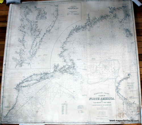
1882 - Eldridge's Chart, Coast of North America, No. 2, Cape Henry to Cape Sable. - Antique Chart
![Black-and-White-Antique--Nautical-Chart-Eldridge's-Chart-Coast-of-North-America-No.-2-Cape-Henry-to-Cape-Sable.--Nautical--1882-Eldridge-Maps-Of-Antiquity]()
- Regular price
- $2,300.00
- Sale price
- $2,300.00
- Regular price
-
- Unit price
- per
Sold out -
1884 - San Francisco Entrance, California - Antique Chart
![Antique-Nautical-Chart-San-Francisco-Entrance-California-1884-USC&GS-1800s-19th-century-Maps-of-Antiquity]()

- Regular price
- $2,800.00
- Sale price
- $2,800.00
- Regular price
-
- Unit price
- per
Sold out -
1887/1900 - Block Island, Rhode Island - Antique Chart
![Genuine-Antique-Nautical-Chart-Block-Island-Rhode-Island--1887/1900-US-Coast-&-Geodetic-Survey-Maps-Of-Antiquity]()

- Regular price
- $2,750.00
- Sale price
- $2,750.00
- Regular price
-
- Unit price
- per
Sold out -
1891 - Admiralty Inlet and Puget Sound to Seattle Washington - Antique Chart
![Impressive black and white sailing chart of part of Puget Sound with the vicinity around Seattle, Washington, from 1891. Dynamic image showing the coastline as it was in the late 1800s, before the major fill projects around Seattle.]()

- Regular price
- $2,500.00
- Sale price
- $2,500.00
- Regular price
-
- Unit price
- per
Sold out -
1893 - The Day Before the Great Naval Review -- The Fleet Passing Castle William on its Way up the Hudson - Antique Print
![Antique-Black-and-White-Print-The-Day-Before-the-Great-Naval-Review----The-Fleet-Passing-Castle-William-on-its-Way-up-the-Hudson-Antique-Prints-Maritime-Prints-1893-Harper's-Weekly-Maps-Of-Antiquity]()

- Regular price
- $950.00
- Sale price
- $950.00
- Regular price
-
- Unit price
- per
Sold out -
1894 - Nantucket Harbor Massachusetts Chart - Antique Chart
![Antique-Nautical-Chart-Nantucket-Harbor-Massachusetts-Chart-Nautical-Cape-Cod-and-Islands-1894-U.S.-Coast-and-Geodetic-Survey-Maps-Of-Antiquity]()

- Regular price
- $850.00
- Sale price
- $850.00
- Regular price
-
- Unit price
- per
Sold out -
1895 - North West Coast of America - Antique Chart
![Antique-Nautical-Chart-North-West-Coast-of-America-Nautical--1895-US-Coast-and-Geodetic-Survey-Maps-Of-Antiquity]()

- Regular price
- $1,200.00
- Sale price
- $1,200.00
- Regular price
-
- Unit price
- per
Sold out -
1904 - Geo. W. Eldridge's Chart C, Vineyard Sound Lt. Ship to Chatham - Antique Chart
![Antique-Nautical-Chart-C-Eldridge's-New-Chart-of-Vineyard-Sound-and-Nantucket-Shoals-Lt-Ship-1904-Eldridge-Cape-Cod-1900s-Maps-of-Antiquity]()

- Regular price
- $1,800.00
- Sale price
- $1,800.00
- Regular price
-
- Unit price
- per
Sold out -
1908 - Geo. W. Eldridge's Chart B New London to Gay Head - Antique Chart
![Antique-Black-And-White-Nautical-Chart-Geo.-W.-Eldridge's-Chart-B-New-London-to-Gay-Head-Nautical-Charts--1908-George-W.-Eldridge-Maps-Of-Antiquity]()

- Regular price
- $1,500.00
- Sale price
- $1,500.00
- Regular price
-
- Unit price
- per
Sold out -
1911 - Geo. W. Eldridge's Chart D, Massachusetts Bay and the Coast from Chatham to Gloucester - Antique Chart
![Black-and-White-Antique-Coastal-Chart--Geo.-W.-Eldridge's-Chart-D-Massachusetts-Bay-and-the-Coast-from-Chatham-to-Gloucester-US-Massachusetts-Massachusetts-General-1911-George-W.-Eldridge-Maps-Of-Antiquity]()

- Regular price
- $1,400.00
- Sale price
- $1,400.00
- Regular price
-
- Unit price
- per
Sold out -
1938 - London Town, Southern Railway - Antique Pictorial Map
![Antique-Map-Pictorial-London-Town-Southern-Railway-1938-Kerry-Lee-Baynard-Press-Maps-of-Antiquity]()

- Regular price
- $1,750.00
- Sale price
- $1,750.00
- Regular price
-
- Unit price
- per
Sold out


- Previous page
- Page 2 of 2