Winter hours: Tuesday - Saturday 10am to 5pm. Close Sundays and Mondays until May. We appreciate your business!

Antique-Hand-Colored-Wall-Map-New-Map-of-that-portion-of-North-America-exhibiting-the-United-States-and-Territories-the-Canadas-New-Brunswick-Nova-Scotia-and-Mexico-also-Central-America-and-the-West-India-Islands.-United-States--1852-Monk-Maps-Of-Antiquity-1800s-19th-century
1852 - New Map of that portion of North America exhibiting the United States and Territories, the Canadas, New Brunswick, Nova Scotia, and Mexico, also, Central America and the West India Islands. - Antique Map
  • Load image into Gallery viewer, Antique-Hand-Colored-Wall-Map-New-Map-of-that-portion-of-North-America-exhibiting-the-United-States-and-Territories-the-Canadas-New-Brunswick-Nova-Scotia-and-Mexico-also-Central-America-and-the-West-India-Islands.-United-States--1852-Monk-Maps-Of-Antiquity-1800s-19th-century
  • Load image into Gallery viewer, 1852 - New Map of that portion of North America exhibiting the United States and Territories, the Canadas, New Brunswick, Nova Scotia, and Mexico, also, Central America and the West India Islands. - Antique Map
  • Load image into Gallery viewer, 1852 - New Map of that portion of North America exhibiting the United States and Territories, the Canadas, New Brunswick, Nova Scotia, and Mexico, also, Central America and the West India Islands. - Antique Map
  • Load image into Gallery viewer, 1852 - New Map of that portion of North America exhibiting the United States and Territories, the Canadas, New Brunswick, Nova Scotia, and Mexico, also, Central America and the West India Islands. - Antique Map
  • Load image into Gallery viewer, 1852 - New Map of that portion of North America exhibiting the United States and Territories, the Canadas, New Brunswick, Nova Scotia, and Mexico, also, Central America and the West India Islands. - Antique Map

1852 - New Map of that portion of North America exhibiting the United States and Territories, the Canadas, New Brunswick, Nova Scotia, and Mexico, also, Central America and the West India Islands. - Antique Map

Regular price
$3,200.00
Sale price
$3,200.00
Regular price
Sold out
Unit price
per 
Shipping calculated at checkout.

Item number: CSMT049MT
Genuine Antique Hand Colored Wall Map

1852

Maker: Monk.

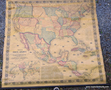
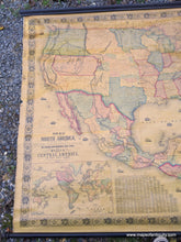
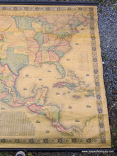
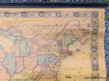
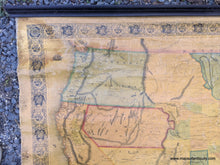
Extremely fine example of the 1852 wall map of the United States with Mexico, part of Canada, and Central America by Jacob Monk, published in 1852. Created at a fascinating time in the history of the United States, this map captures the era of western expansion that shaped the country. In the East, the focus is on transportation routes, especially railroads, with information about proposed routes with tables of distances. In the West we find the newest state in the Union, California, in the height of the gold rush with a large area marked on the map as the Gold Region. Also in the west are Oregon Territory, Utah Territory and New Mexico Territory. The names of many Native American peoples are included throughout the West. The mountain ranges are also very interesting, as are the trails and routes across the country, including the Oregon Trail, called Emigrant's Route on the map. In the lower left of the map is an inset of the world mapped on Mercator's Projection. Additional delightful details include ships throughout the seas and a highly decorative border. This map is in very good unrestored condition. Some damage and stains in the upper corners and on the left side. Some areas where the varnish is thinner appear lighter. On original wooden rods. Measures approx. 60 x 67 including the rods, or 55 x 59 inches to the neatline. **NOTE- because this map requires extra insurance for shipping, an additional charge will appear on your card after your original purchase. If you would like to know what that charge will be, please contact us.**

Item Number: CSMT049MT