Current hours: 10am to 5pm Monday through Saturday. 12pm to 5pm Sundays. We are CLOSED on Christmas Day and New Years Day. We will close early (3pm) on Christmas Eve. IMPORTANT PLEASE NOTE: We have become aware that some of our photos have been stolen by other websites. Our maps are only available at our website www.mapsofantiquity.com or at our store!

Original-Map-Chatham-Pictorial-Street-1961-Antique-Chamber-Commerce-illustrations-points-of-interest-1960s-20th-century

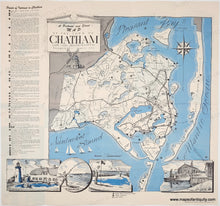
1961 - A Pictorial and Street Map of the Town of Chatham - Antique Pictorial Map

Regular price
$115.00
Sale price
$115.00
Regular price
$125.00
Sold out
Unit price
per 
Shipping calculated at checkout.

Item number: MAS1730

Original Printed Color Map

1961

Maker: Brooks/Chatham Chamber.


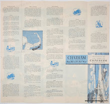
Original printed color map from 1961 of the town of Chatham, MA, published by the town of Chatham with map and art by Robert Brooks. This is a folding map with the map and points of interest on one side and a lot of local information on the verso. The images on the bottom feature one of the lighthouses, fishing, golfing, and the fish pier. Good overall antique condition with folds as issued and light overall toning. Some wear along the folds not visible in the photo- if you would like a current photo, please contact us. Measures approx. 18.5 x 20 inches to the paper edges.

Price reflects condition.

Item Number: MAS1730