Current hours: 10am to 5pm Monday through Saturday. 12pm to 5pm Sundays. IMPORTANT PLEASE NOTE: We have become aware that some of our photos have been stolen by other websites. Our maps are only available at our website www.mapsofantiquity.com or at our store!

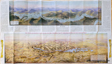
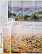
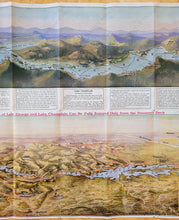
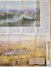
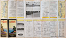
Antique folding map with a bird's-eye view map of Lake George, New York, at the top in colored of blues, greens, and purples, and a slightly larger bird's-eye view map of Lake Champlain and Lake George at the bottom in colors of yellow, green, blue, and red. Coloring is sophisticated chromolithograph color and shows the majestic mountains and hills around the lakes. Maps also include towns, railroads, and more. Text is printed around the outside of the maps with visitor information.
1925 - Lake George And Champlain Antique Map Genuine
  • Load image into Gallery viewer, Antique folding map with a bird's-eye view map of Lake George, New York, at the top in colored of blues, greens, and purples, and a slightly larger bird's-eye view map of Lake Champlain and Lake George at the bottom in colors of yellow, green, blue, and red. Coloring is sophisticated chromolithograph color and shows the majestic mountains and hills around the lakes. Maps also include towns, railroads, and more. Text is printed around the outside of the maps with visitor information.
  • Load image into Gallery viewer, Antique folding map with a bird's-eye view map of Lake George, New York, at the top in colored of blues, greens, and purples, and a slightly larger bird's-eye view map of Lake Champlain and Lake George at the bottom in colors of yellow, green, blue, and red. Coloring is sophisticated chromolithograph color and shows the majestic mountains and hills around the lakes. Maps also include towns, railroads, and more. Text is printed around the outside of the maps with visitor information.
  • Load image into Gallery viewer, Antique folding map with a bird's-eye view map of Lake George, New York, at the top in colored of blues, greens, and purples, and a slightly larger bird's-eye view map of Lake Champlain and Lake George at the bottom in colors of yellow, green, blue, and red. Coloring is sophisticated chromolithograph color and shows the majestic mountains and hills around the lakes. Maps also include towns, railroads, and more. Text is printed around the outside of the maps with visitor information.
  • Load image into Gallery viewer, Antique folding map with a bird's-eye view map of Lake George, New York, at the top in colored of blues, greens, and purples, and a slightly larger bird's-eye view map of Lake Champlain and Lake George at the bottom in colors of yellow, green, blue, and red. Coloring is sophisticated chromolithograph color and shows the majestic mountains and hills around the lakes. Maps also include towns, railroads, and more. Text is printed around the outside of the maps with visitor information.
  • Load image into Gallery viewer, Antique folding map with a bird's-eye view map of Lake George, New York, at the top in colored of blues, greens, and purples, and a slightly larger bird's-eye view map of Lake Champlain and Lake George at the bottom in colors of yellow, green, blue, and red. Coloring is sophisticated chromolithograph color and shows the majestic mountains and hills around the lakes. Maps also include towns, railroads, and more. Text is printed around the outside of the maps with visitor information.
  • Load image into Gallery viewer, 1925 - Lake George And Champlain Antique Map Genuine

1925 - Lake George and Lake Champlain - Antique Map

Regular price
$325.00
Sale price
$325.00
Regular price
Sold out
Unit price
per 
Shipping calculated at checkout.

Item number: NYO1028

Genuine Antique Map

1925

Maker: Lake George Steamboat Company


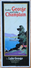
This printed color antique bird's-eye-view map was published in 1925 by the Delaware & Hudson Company, the Champlain Transportation Company, and the Lake George Steamboat Company. The map has an artist signature of H.H. Green and copyright by A.A. Heard, 1911, and it was published as a travel brochure highlighting the Lake George, Lake Champlain area. The upper map focuses on Lake George including hotels, lodges, clubs, and the steamboat route. The lower map stretches from Albany on the left to Montreal on the right and includes Schenectady, Rutland, Burlington, Plattsburg, Fort William Henry, the St Lawrence River, and more. Text around the map goes into the history and tourism of the area. Verso has detailed tourism information. With folds as issued. Very good antique condition with some mild wear along the folds including some small holes at the fold intersections. When the brochure is folded out completely, it measures approx. 18.5 x 32.5 inches to the paper edges.


Item Number: NYO1028