Current hours: 10am to 5pm Tuesday through Saturday. We are closed Sundays and Mondays for the Winter. IMPORTANT PLEASE NOTE: We have become aware that some of our photos have been stolen by other websites. Our maps are only available at our website www.mapsofantiquity.com or at our store!

Antique-Printed-Color-Map-View-of-the-Center-of-Paris-taken-from-the-air-Towns-and-Cities-Paris-1950-Blondel-la-Rougery-Maps-Of-Antiquity
1950 - View Of The Center Paris Taken From Air Antique Map Genuine Printed-Color
  • Load image into Gallery viewer, Antique-Printed-Color-Map-View-of-the-Center-of-Paris-taken-from-the-air-Towns-and-Cities-Paris-1950-Blondel-la-Rougery-Maps-Of-Antiquity
  • Load image into Gallery viewer, 1950 - View Of The Center Paris Taken From Air Antique Map Genuine Printed-Color
  • Load image into Gallery viewer, 1950 - View Of The Center Paris Taken From Air Antique Map Genuine Printed-Color
  • Load image into Gallery viewer, 1950 - View Of The Center Paris Taken From Air Antique Map Genuine Printed-Color

1950 - View of the Center of Paris taken from the air - Antique Map

Regular price
$275.00
Sale price
$275.00
Regular price
Sold out
Unit price
per 
Shipping calculated at checkout.

Item number: TOW419
Genuine Antique Printed Color Map

1950

Maker: Blondel la Rougery.

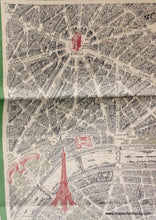
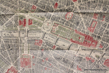
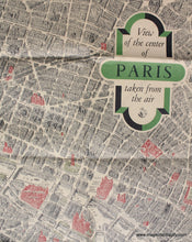
Antique printed color map of Paris by Blondel le Rougery, published in 1950. Detailed renderings of buildings, gardens, parks, monuments, with boats on the Seine and places of interest colored red. Includes the Eiffel Tower, the Louvre, Notre Dame, Arc de Triomphe, and many more. This was issued as a folding map anf it retains its folds. Very good condition with some tack holes in the margins. Approx. 26.25 x 42.75 inches

Item Number: TOW419