Winter hours: Tuesday - Saturday 10am to 5pm. Close Sundays and Mondays until May. We appreciate your business!

Antique-Hand-Colored-Map-Map-of-Boston-and-the-Country-Adjacent-United-States-Massachusetts-1892-Walker-Maps-Of-Antiquity
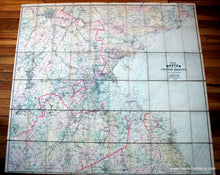
1892 - Map of Boston and the Country Adjacent - Antique Map
  • Load image into Gallery viewer, Antique-Hand-Colored-Map-Map-of-Boston-and-the-Country-Adjacent-United-States-Massachusetts-1892-Walker-Maps-Of-Antiquity
  • Load image into Gallery viewer, 1892 - Map of Boston and the Country Adjacent - Antique Map
  • Load image into Gallery viewer, 1892 - Map of Boston and the Country Adjacent - Antique Map
  • Load image into Gallery viewer, 1892 - Map of Boston and the Country Adjacent - Antique Map

1892 - Map of Boston and the Country Adjacent - Antique Map

Regular price
$550.00
Sale price
$550.00
Regular price
Sold out
Unit price
per 
Shipping calculated at checkout.

Item number: TOW373BOS
Genuine Antique Hand Colored Map

1892

Maker: Walker.

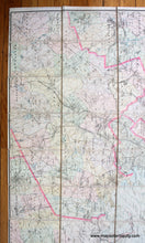
Hand colored antique Walker map of Boston and surrounding towns, from Rockport to Duxbury, and Tyngsborough to Franklin, Mass, with circumference lines showing distance from downtown Boston, Massachusetts, published by Damrell and Upham. This map shows interesting detail of land features, coastal water depths, topography, railroad lines, major roads, and town borders in original color, mounted on fine linen, folded map with 60 squares, flattens nicely for framing, in very good condition, 42 x 48 inches. **NOTE- because this map requires extra insurance for shipping, an additional charge will appear on your card after your original purchase. If you would like to know what that charge will be, please contact us.**

Item Number: TOW373BOS