Current hours: 10am to 5pm Tuesday through Saturday. We are closed Sundays and Mondays for the Winter. IMPORTANT PLEASE NOTE: We have become aware that some of our photos have been stolen by other websites. Our maps are only available at our website www.mapsofantiquity.com or at our store!

Antique-Hand-Colored-Coastal-Chart-Crescent-City-Harbor-California--California--1859-US-Coast-Survey-Maps-Of-Antiquity
1859 - Crescent City Harbor California Antique Chart Genuine Hand-Colored Coastal
  • Load image into Gallery viewer, Antique-Hand-Colored-Coastal-Chart-Crescent-City-Harbor-California--California--1859-US-Coast-Survey-Maps-Of-Antiquity
  • Load image into Gallery viewer, 1859 - Crescent City Harbor California Antique Chart Genuine Hand-Colored Coastal

1859 - Crescent City Harbor, California - Antique Chart

Regular price
$150.00
Sale price
$150.00
Regular price
Sold out
Unit price
per 
Shipping calculated at checkout.

Item number: WES177
Genuine Antique Hand Colored Coastal Chart

1859

Maker: US Coast Survey.

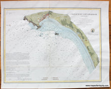
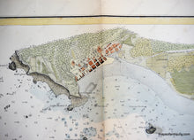
Hand colored antique coastal chart of Crescent City, California in the mid-19th century, before landfill and breakwaters connected Steamboat Rock and Whalers Island to the mainland, including very fine detail of topography, and of the few waterfront streets and buildings of the town at the time. With detailed information on soundings, Crescent City Lighthouse and Sailing Directions. Very good condition, restored and rebacked with light-weight paper, hand coloring is recent, measures approx. 12 x 15.5 inches.

Item Number: WES177