Current hours: 10am to 5pm Tuesday through Saturday. We are closed Sundays and Mondays for the Winter. IMPORTANT PLEASE NOTE: We have become aware that some of our photos have been stolen by other websites. Our maps are only available at our website www.mapsofantiquity.com or at our store!

Antique-Uncolored-Pictorial-Map-Nantucket-Island-**********-United-States-Massachusetts-c.-1932-New-England-Map-Co./L.-Parker-Maps-Of-Antiquity
  • Load image into Gallery viewer, Antique-Uncolored-Pictorial-Map-Nantucket-Island-**********-United-States-Massachusetts-c.-1932-New-England-Map-Co./L.-Parker-Maps-Of-Antiquity
  • Load image into Gallery viewer, Antique-Uncolored-Pictorial-Map-Nantucket-Island-**********-United-States-Massachusetts-c.-1932-New-England-Map-Co./L.-Parker-Maps-Of-Antiquity

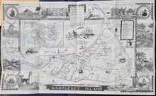
1940 - Nantucket Island - Antique Pictorial Map

Regular price
$295.00
Sale price
$295.00
Regular price
Sold out
Unit price
per 
Shipping calculated at checkout.

Item number: MAS1547
Genuine Antique Uncolored Pictorial Map

c. 1940

Maker: New England Map Co./L. Parker.


Antique black & white printed tourist map of Nantucket with many quirky details including a border depicting woven rope, numerous vignettes, an island history, and drawings of island activities, including a key to Points of Interest. "Come Get a Perfect Vacation on this Fascinating Island 30 Miles at Sea...."  Very good overall antique condition with folds as issued and mild wear along the folds. This is a folding map that folded down into a cover to make it pocket-sized. The cover is attached. Measures approx. 18 x 30.5 inches unfolded.


Item Number: MAS1547