Antique-Hand-Colored-Map-North-Chatham-Index-Map-to-the-Town-of-Orleans-Page-42-(MA)-Massachusetts-Cape-Cod-and-Islands-1906-Walker-Maps-Of-Antiquity
  • Load image into Gallery viewer, Antique-Hand-Colored-Map-North-Chatham-Index-Map-to-the-Town-of-Orleans-Page-42-(MA)-Massachusetts-Cape-Cod-and-Islands-1906-Walker-Maps-Of-Antiquity
  • Load image into Gallery viewer, Antique-Hand-Colored-Map-North-Chatham-Index-Map-to-the-Town-of-Orleans-Page-42-(MA)-Massachusetts-Cape-Cod-and-Islands-1906-Walker-Maps-Of-Antiquity

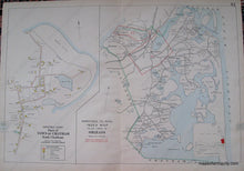
1906 - Index Map to the Town of Orleans, with North Chatham, Page 42 (MA) - Antique Map

Regular price
$450.00
Sale price
$450.00
Regular price
Sold out
Unit price
per 
Shipping calculated at checkout.

Item number: MAS1307
Genuine Antique Hand Colored Map

1906

Maker: Walker.


Antique hand colored map from Walker's 1906 Atlas of Barnstable County. Every property owner at the time is labeled. Areas outlined in red are enlarged on another sheet. Priced as Very good overall antique condition. Other pieces may be available in other conditions, priced accordingly. Double sheet measures approximately 21 x 30 inches. **NOTE- because this map requires extra insurance for shipping, an additional charge will appear on your card after your original purchase. If you would like to know what that charge will be, please contact us.**


Item Number: MAS1307