Pickup available at 1409 MAIN ST, CHATHAM MA
Usually ready in 24 hours
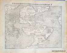
1550 - The New World - Die Neuwen Inseln / So hinder Hispanien gegen Orient ven dem land Indie ligen - Antique Map
-
1409 MAIN ST, CHATHAM MA
Pickup available, usually ready in 24 hours1409 Main Street
Chatham MA 02633
United States+15089451660
Item number: CSMT117
Genuine Antique Map
1550
Maker: Munster
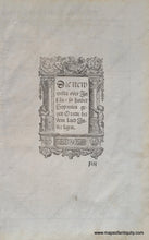
An extremely early and rare collectible map of the Americas published by Munster in 1550 (fifth state). The first edition of this map was printed in 1540 and it was included in Munster's publications of Ptolemy's Geographia from 1540 to 1578. It includes the recently discovered Straits of Magellan with a depiction of Magellan's ship, the first depiction of Japan on a map (labeled Zipangri), the Sea of Verrazano separating Terra Florida and Francisca (Verrazano mistook the Pamlico and Albemarle Sounds as the Pacific Ocean, and thus the myth of the Sea of Verrazano began), and a graphic depiction of cannibals. The flags indicated the division of the New World between Spain and Portugal. Munster's map served to popularize the belief in a Northwest Passage, thereby encouraging more exploration of the area by both the French and the British. This map will reward the collector who takes the time to study it. Very good condition with minor toning and signs of age. May have been cleaned or restored by a previous owner. Measures approx. 10 x 13.5 inches to the neatline. See photo of the printing on back, which is not visible on front.
Item Number: CSMT117


