Winter hours: Tuesday - Saturday 10am to 5pm. Close Sundays and Mondays until May. We appreciate your business!

Genuine-Antique-Printed-Color-Comparative-Chart-Star-Map-No.-1;-verso:-Star-Map-No.-2-Celestial--1892-Home-Library-&-Supply-Association-Maps-Of-Antiquity-1800s-19th-century
1892 - Star Map No. 1; verso: Star Map No. 2 - Antique Chart
  • Load image into Gallery viewer, Genuine-Antique-Printed-Color-Comparative-Chart-Star-Map-No.-1;-verso:-Star-Map-No.-2-Celestial--1892-Home-Library-&-Supply-Association-Maps-Of-Antiquity-1800s-19th-century
  • Load image into Gallery viewer, 1892 - Star Map No. 1; verso: Star Map No. 2 - Antique Chart

1892 - Star Map No. 1; verso: Star Map No. 2 - Antique Chart

Regular price
$55.00
Sale price
$55.00
Regular price
Sold out
Unit price
per 
Shipping calculated at checkout.

Item number: CEL118
Genuine Antique Printed Color Comparative Chart

1892

Maker: Home Library & Supply Association.

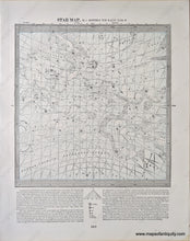
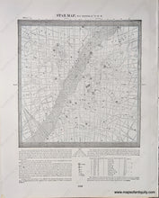
Antique printed color double-sided maps published in "The Pacific Coast and the World" by the Home Library and Supply Association, 1892. Star Map No. 1 includes the constellations of Aquarius, Aries, the Whale, Pisces, Pegasus, Adromeda, and more. Star Map No. 2 includes Cancer, Gemini, Taurus, Orion, and more. Very good overall antique condition with some very mild toning/foxing (mainly at the outer edges.) Measure approx. 9.75 x 8.75 inches to the neatline.

Item Number: CEL118