Current hours: 10:30am to 5pm Tuesday through Saturday. We are closed Sundays and Mondays for the Winter. IMPORTANT PLEASE NOTE: We have become aware that some of our photos have been stolen by other websites. Our maps are only available at our website www.mapsofantiquity.com or at our store!

Antique-Printed-Color-Map-States-of-Delaware-and-Maryland-1848-Goodrich-United-States-Mid-Atlantic1800s-19th-century-Maps-of-Antiquity
1848 - States Of Delaware And Maryland Antique Map Genuine Printed-Color
  • Load image into Gallery viewer, Antique-Printed-Color-Map-States-of-Delaware-and-Maryland-1848-Goodrich-United-States-Mid-Atlantic1800s-19th-century-Maps-of-Antiquity
  • Load image into Gallery viewer, 1848 - States Of Delaware And Maryland Antique Map Genuine Printed-Color

1848 - States of Delaware and Maryland - Antique Map

Regular price
$40.00
Sale price
$40.00
Regular price
Sold out
Unit price
per 
Shipping calculated at checkout.

Item number: MAT255
Genuine Antique Printed Color Map

1848

Maker: Goodrich.

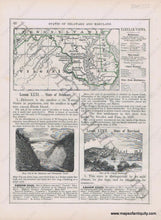
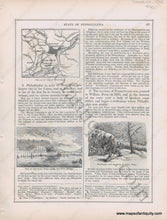
Antique early printed color outlined two-sided page from A National Geography for Schools written by S.G. Goodrich and published by Huntington and Savage in 1848, with engravings including a View of the City of Baltimore, Deep Cut in the Delaware and Chesapeake Canal, verso includes Plan of the City of Philadelphia, Washington and his Army at Valley Forge, and a View of the Fairmount Water-work and Wire Bridge, with text and tables describing the region, etc. In very good antique condition with minor toning, foxing and general signs of age, page measures approximately 10.5 x 8.5 inches.

Item Number: MAT255