Current hours: 10am to 5pm Monday through Saturday. 12pm to 5pm Sundays. IMPORTANT PLEASE NOTE: We have become aware that some of our photos have been stolen by other websites. Our maps are only available at our website www.mapsofantiquity.com or at our store!

Genuine-Antique-Hand-colored-Map-Luxembourg-Germany-Trevisensis-Arch-Episcopatus-et-Electoratus---Seutter-Maps-Of-Antiquity
  • Load image into Gallery viewer, Genuine-Antique-Hand-colored-Map-Luxembourg-Germany-Trevisensis-Arch-Episcopatus-et-Electoratus---Seutter-Maps-Of-Antiquity
  • Load image into Gallery viewer, Genuine-Antique-Hand-colored-Map-Luxembourg-Germany-Trevisensis-Arch-Episcopatus-et-Electoratus---Seutter-Maps-Of-Antiquity
  • Load image into Gallery viewer, Genuine-Antique-Hand-colored-Map-Luxembourg-Germany-Trevisensis-Arch-Episcopatus-et-Electoratus---Seutter-Maps-Of-Antiquity

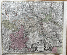
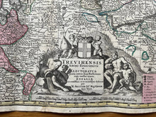
1740 - Germany - Trevisensis Arch-Episcopatus et Electoratus. - Antique Map

Regular price
$250.00
Sale price
$250.00
Regular price
Sold out
Unit price
per 
Shipping calculated at checkout.

Item number: CSMT071
Genuine Antique Hand-colored Map

c. 1740

Maker: Seutter


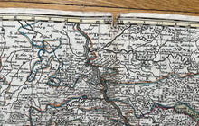
This antique map of Luxembourg and Germany, includes the Rhine and Mosel Rivers, Coblentz/Koblenz, Bonn, Dusseldorf, Bingen, Trier. Published c. 1740. In overall good antique condition with edge-wear and 3/4 inch tear in top center seam, with excellent color, measures about 19 1/2h x 23"w. Price reflects condition.


Item Number: CSMT071