1884
Maker: Walker.
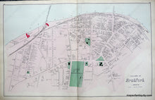
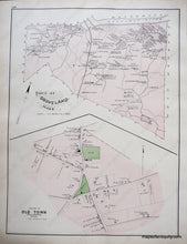
Antique hand colored maps of the Village of Bradford, and the Town, the Town of Groveland, and the Village of Old Town within the Town of Newbury, MA, from Walker's 1884 Atlas of Essex County. Side one depicts the Village of Bradford before it was annexed to the City of Haverhill in 1897, and shows public buildings and areas, churches, the Merrimack River, railroads, roads, schools, including Bradford Academy (the now defunct Bradford College), and businesses, including J.P. Gilman and Sons Hat Manufactory. Side two displays the Town of Groveland and the Village of Old Town in Newbury, including buildings with owners' names, public buildings and areas,water bodies, landforms, islands, railroads, roads, and schools. Very good overall antique condition with light overall toning and original colorist's mistakes as issued. Center spread of Bradford measures approx. 16 x 25.5 inches, verso maps about half that size.
Item Number: MAS1659


