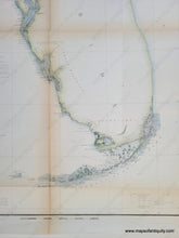
1853
Maker: U.S. Coast Survey.
Antique hand-colored coastal report chart of part of Florida, published by the United States Coast Survey, 1853. Features an inset map of the region north of the St. Johns River. Includes sailing directions and information regarding locations of astronomical stations, magnetic stations, current stations, tidal stations, etc. Also includes a table of latitudes and longitudes for key points on the coast (e.g. St. Marks Light, Key West Light, etc.) Great representation of Florida Keys. With folds, as issued. Good overall antique condition with mild toning that is slightly darker along the folds, some tiny spots. Measures approximately 23" x 16.25" to the neatline.
Item Number: SOU372


