Current hours: 10:30am to 5pm Tuesday through Saturday. We are closed Sundays and Mondays for the Winter. IMPORTANT PLEASE NOTE: We have become aware that some of our photos have been stolen by other websites. Our maps are only available at our website www.mapsofantiquity.com or at our store!

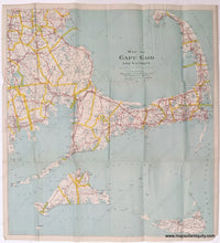
1922 - Map of Cape Cod and Vicinity - Antique Map
1922 - Map Of Cape Cod And Vicinity Antique Genuine Lithograph Road Folding In Paper Jacket
  • Load image into Gallery viewer, 1922 - Map of Cape Cod and Vicinity - Antique Map
  • Load image into Gallery viewer, 1922 - Map Of Cape Cod And Vicinity Antique Genuine Lithograph Road Folding In Paper Jacket

1922 - Map of Cape Cod and Vicinity - Antique Map

Regular price
$325.00
Sale price
$325.00
Regular price
Sold out
Unit price
per 
Shipping calculated at checkout.

Item number: MAS509
Genuine Antique Lithograph Road Map, folding, with paper jacket

1922

Maker: Walker.


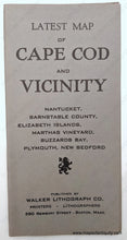
Antique lithograph road map of Cape Cod, Martha's Vineyard, and Nantucket, by Walker, c. 1922. This map includes the railway on Nantucket and the Chatham extension but no railway on Martha's Vineyard. The main roads are numbered, a change that took place in 1922, so this was likely printed shortly after to reflect the change. Issued as a folding map, this map comes with a paper jacket. We are currently flattening this map to reduce the folds. Very good overall condition, with some tiny spots and some wrinkling. Map measures approx. 20.25 x 18.75 inches to neatline.


Item Number: MAS509