Current hours: 10am to 5pm Monday through Saturday. Closed on Sundays. IMPORTANT PLEASE NOTE: We have become aware that some of our photos have been stolen by other websites. Our maps are only available at our website www.mapsofantiquity.com or at our store!

Genuine-Antique-Map-Map-of-Boston-published-by-Hotel-Rexford-with-Compliments-1899-Walker-Maps-Of-Antiquity
  • Load image into Gallery viewer, Genuine-Antique-Map-Map-of-Boston-published-by-Hotel-Rexford-with-Compliments-1899-Walker-Maps-Of-Antiquity
  • Load image into Gallery viewer, Genuine-Antique-Map-Map-of-Boston-published-by-Hotel-Rexford-with-Compliments-1899-Walker-Maps-Of-Antiquity

1899 - Map of Boston published by Hotel Rexford with Compliments - Antique Map

Regular price
$95.00
Sale price
$95.00
Regular price
Sold out
Unit price
per 
Shipping calculated at checkout.

Item number: MAS2300
Genuine Antique Map

1899

Maker: Walker

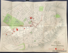
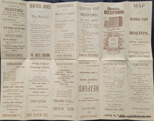
Antique tourism map of the center of Boston, copyright 1899 by Walker. This map shows North and South Stations, North End Park, the Boston Common, the Public Garden, public buildings, theaters and museums, Hotel Rexford (the sponsor of the map), streetcar tracks, and most notably, the subway, which was brand new. Boston's subway was the first in the United States and is often called "America's First Subway" by the MBTA and others. In 1897 and 1898, the Tremont Street subway opened as the core of the precursor to the Green Line. Backside has tourism recommendations from the Hotel Rexford. Very good condition with a few tiny spots. Printed on light-weight paper. Measures approx. 12.5 x 16.5 inches to the neatline.

Item Number: MAS2300