Pickup available at 1409 MAIN ST, CHATHAM MA
Usually ready in 24 hours
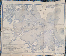
1896 - Correct Map of Boston Harbor giving Route and Official Summer Time-Table of the Nantasket Beach Steamboat Co. Commencing July 1, 1896. - Antique Map
-
1409 MAIN ST, CHATHAM MA
Pickup available, usually ready in 24 hours1409 Main Street
Chatham MA 02633
United States+15089451660
Item number: MAS2448
Genuine Antique Map
1896
Maker: Bouve, Crawford & Co.
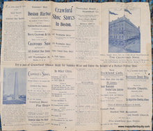
Antique map of Boston Harbor published by Bouve, Crawford & Co. in 1896. These useful maps were published annually with the route and times of the Nantasket Beach Steamboat Co, which brought travelers from Boston to Nantasket. The company that produced them was the proprietor of the Crawford Shoe Stores, of which there were five locations in Boston, all shown on the map. Includes railroads, towns, the many islands with their names, and a note of the location of the wreck of the steamer Venetian (1895). Although many were produced, these are not common on the market, so it is likely that few survived the years. Good antique condition with some small holes mostly in the margins, some folds and wear at the paper edges, small separations at the fold intersections, and a stain on the left side. Measures approx. 12.5 x 15.75 inches to the neatline.
Item Number: MAS2448


