Current hours: 10am to 5pm Monday through Saturday. Closed on Sundays. IMPORTANT PLEASE NOTE: We have become aware that some of our photos have been stolen by other websites. Our maps are only available at our website www.mapsofantiquity.com or at our store!

Genuine-Antique-Geological-Map-Geological-Map-of-the-Middle-and-Western-States-1843-James-Hall-Maps-Of-Antiquity
  • Load image into Gallery viewer, Genuine-Antique-Geological-Map-Geological-Map-of-the-Middle-and-Western-States-1843-James-Hall-Maps-Of-Antiquity
  • Load image into Gallery viewer, Genuine-Antique-Geological-Map-Geological-Map-of-the-Middle-and-Western-States-1843-James-Hall-Maps-Of-Antiquity
  • Load image into Gallery viewer, Genuine-Antique-Geological-Map-Geological-Map-of-the-Middle-and-Western-States-1843-James-Hall-Maps-Of-Antiquity

1843 - Geological Map of the Middle and Western States - Antique Map

Regular price
$850.00
Sale price
$850.00
Regular price
Sold out
Unit price
per 
Shipping calculated at checkout.

Item number: MWE507
Genuine Antique Geological Map

1843

Maker: James Hall


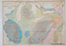
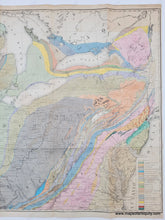
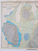
Hand colored antique map of the Midwest by James Hall, 1843. The map covers most of the states of Illinois and Wisconsin in the west, to the New Jersey, Maryland and New York coast in the east. The Great Lakes (except for Superior) are included and it extends as far south as the Kentucky / Tennessee border. Includes Indiana, Michigan, Ohio, Virginia, Pennsylvania, and part of Canada as well. The map is color coded by 23 geological formations with a key in the lower right. Hall's map can be regarded as a landmark work as it was one of the earliest known maps to employ the "New York System," of stratigraphic nomenclature developed by Hall and others at the New York Geological Survey. This map is the first regional application of the system, which evolved into the standard nomenclature used today for North America and much of the rest of the world. Very good condition with some areas where the toning is darker, some minor tiny spots. Folds as issued. Measures approx. 23 x 32.5 inches to the neatline.  **NOTE- because this map requires extra insurance for shipping, an additional charge will appear on your card after your original purchase. If you would like to know what that charge will be, please contact us.**


Item Number: MWE507