Current hours: 10am to 5pm Tuesday through Saturday. We are closed Sundays and Mondays until late May. Proud to be a SMALL, LOCAL, CAPE COD BUSINESS! Maps of Antiquity is in its 38th year! Our maps are only available at our website www.mapsofantiquity.com or at our store!

Printed-Color-Antique-Map-Poitou-Vendee-Charentes-c.-1947-French-Ministry-of-Travel-France-1900s-20th-century-Maps-of-Antiquity
1947 - Poitou Vendee Charentes Antique Map Printed-Color Genuine
  • Load image into Gallery viewer, Printed-Color-Antique-Map-Poitou-Vendee-Charentes-c.-1947-French-Ministry-of-Travel-France-1900s-20th-century-Maps-of-Antiquity
  • Load image into Gallery viewer, 1947 - Poitou Vendee Charentes Antique Map Printed-Color Genuine

1947 - Poitou, Vendee, Charentes - Antique Map

Regular price
$75.00
Sale price
$75.00
Regular price
Sold out
Unit price
per 
Shipping calculated at checkout.
 More payment options

Item number: EUR2465
Printed Color Genuine Antique Map

c. 1947

Maker: French Ministry of Travel.

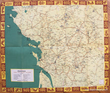
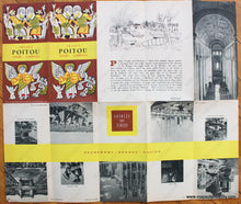
Antique printed color folding tourist map of the areas near Poitiu, Vendee, Aunis, Saintonge, and Angoumois, France, published by the French Ministry of Travel, in English, including Nantes, Poitiers, Limoges, Fontenay-le-Comte, Saintes, and Perigueux, with roads, towns, villages, natural curiosities, religious edifices, megalithic monuments, battlefields, castles, spas, and more. Verso features narrative of the area and photographs of famous tourist attractions, c. 1947. Very good condition with vivid original color, pin holes at corners, measures approx. 17.5 x 20.5 inches unfolded.

Item Number: EUR2465