1676
Maker: Speed
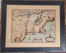
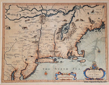
Highly collectible antique map of New England, engraved by Francis Lamb, published in the last edition of John Speed's atlas, 1676. An important map of the British colonies in North America, based on the Jansson/Visscher maps that formed the foundation for maps of the region. It shows the east coast from Maryland and New Jersey to the French possessions in Canada and includes New England and New York with a prominent Cape Cod and Long Island, and interestingly shaped Nantucket and Martha's Vineyard. It is the first appearance of the name Boston, and the first map to use the term New York for both Manhattan and the colony. It is also one of the first maps to show New Jersey. Notable on this map are the river systems and enlarged Lake Champlain, which emphasize how little was truly known during this early colonial period, and it was produced shortly after the British capture of New Amsterdam in 1664, which radically shifted European influence in the colonies from the Dutch to the English. The map is embellished with decoration on the cartouche and scale of miles, two compass roses, and various animals are depicted inland, including beavers, two of whom are eating fish... a myth that still confuses some people today (beavers are herbivores). Vibrant recent color. Although this map is often referred to as "Speed’s Map of New England" this famous map was engraved by Francis Lamb for inclusion in the last edition of Speed’s popular atlas, published by Basset and Chiswell, 47 years after Speed's death. On the verso is text in English that offers fascinating information on the colonies. Framed recently with archival materials. Map measures approx. 15 x 19.75 inches to the neatline and total dimensions are 23.5 x 28.75 inches including the frame. **NOTE: shipping may need to be specially calculated for this map to include full insurance- please contact us if you would like to know in advance what the shipping will cost.
Item Number: CSMT067


