Current hours: 10am to 5pm Monday through Saturday. 12pm to 5pm Sundays. IMPORTANT PLEASE NOTE: We have become aware that some of our photos have been stolen by other websites. Our maps are only available at our website www.mapsofantiquity.com or at our store!

Genuine-Antique-Map-Carte-de-la-Louisiane-et-du-Cours-du-Mississipi-1st-state--1718-Guillaume-de-L-Isle-Maps-Of-Antiquity
  • Load image into Gallery viewer, Genuine-Antique-Map-Carte-de-la-Louisiane-et-du-Cours-du-Mississipi-1st-state--1718-Guillaume-de-L-Isle-Maps-Of-Antiquity
  • Load image into Gallery viewer, Genuine-Antique-Map-Carte-de-la-Louisiane-et-du-Cours-du-Mississipi-1st-state--1718-Guillaume-de-L-Isle-Maps-Of-Antiquity
  • Load image into Gallery viewer, Genuine-Antique-Map-Carte-de-la-Louisiane-et-du-Cours-du-Mississipi-1st-state--1718-Guillaume-de-L-Isle-Maps-Of-Antiquity
  • Load image into Gallery viewer, Genuine-Antique-Map-Carte-de-la-Louisiane-et-du-Cours-du-Mississipi-1st-state--1718-Guillaume-de-L-Isle-Maps-Of-Antiquity
  • Load image into Gallery viewer, Genuine-Antique-Map-Carte-de-la-Louisiane-et-du-Cours-du-Mississipi-1st-state--1718-Guillaume-de-L-Isle-Maps-Of-Antiquity
  • Load image into Gallery viewer, Genuine-Antique-Map-Carte-de-la-Louisiane-et-du-Cours-du-Mississipi-1st-state--1718-Guillaume-de-L-Isle-Maps-Of-Antiquity
  • Load image into Gallery viewer, Genuine-Antique-Map-Carte-de-la-Louisiane-et-du-Cours-du-Mississipi-1st-state--1718-Guillaume-de-L-Isle-Maps-Of-Antiquity
  • Load image into Gallery viewer, Genuine-Antique-Map-Carte-de-la-Louisiane-et-du-Cours-du-Mississipi-1st-state--1718-Guillaume-de-L-Isle-Maps-Of-Antiquity
  • Load image into Gallery viewer, Genuine-Antique-Map-Carte-de-la-Louisiane-et-du-Cours-du-Mississipi-1st-state--1718-Guillaume-de-L-Isle-Maps-Of-Antiquity

1718 - Carte de la Louisiane et du Cours du Mississipi (1st state) - Antique Map

Regular price
$5,600.00
Sale price
$5,600.00
Regular price
$7,000.00
Sold out
Unit price
per 
Shipping calculated at checkout.

Item number: CSMT142
Genuine Antique Map

1718

Maker: Guillaume de L'Isle

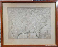
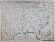
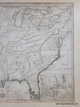
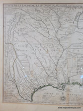
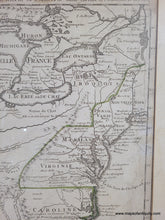
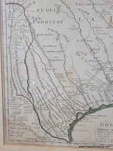
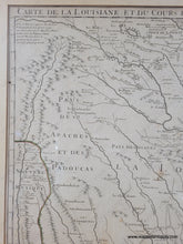
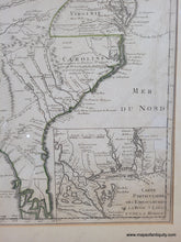
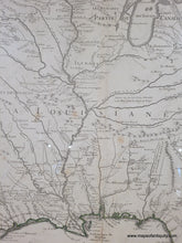
Fantastic early map of part of North America that would later become the United States, by Guillaume de L'Isle, 1718. This map is considered one of the most important maps of the North American continent, the main source of the maps of the Mississippi that were drawn later by Homann, Moll, Senex, Seutter, etc. It is an impressive map covering the area from New Mexico to Florida and Montreal, and includes the Great Lakes, Gulf of Mexico, and Atlantic Coast. This map, produced by a French mapmaker, shows biased French claims on the new continent- De L'Isle included Florida in the French territory, and also shrunk the areas claimed by Britain. This sparked outrage and the Spanish and British rushed to create maps in response to correct these intentional errors. This map is also the first to make any mention of Texas (a small note reading "Mission de los Teijas etablie en 1716" can be seen near the Trinity River). Shows the locations of major settlements, forts, and topographical features, and includes the routes of explorers such as de Soto, Moscoso, La Salle, de Leon, and St. Denis, along with the dates of their expeditions. Signifiant notes throughout the map cover various topics, including the native people, the naming of Carolina (which the map claims was named by the French, when in fact the British were the first Europeans there and named the area), and many other subjects. A fascinating map, reflecting the politics and biases of the time, with impressive detail and accuracy, which makes it a desirable map for any collector. Very good condition, framed, with some foxing/stains. The framing does not appear to be archival and the map should be reframed, therefore if it is purchased online, it will be shipped unframed. This map has not yet been removed from the frame and may be attached to a board- please contact us if you are interested and wish to know for sure. It measures approx. 19.25 x 25.75 inches to the neatline. Please forgive the small amounts of glare on the glass in the photos.

Item Number: CSMT142