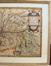
1579
Maker: Ortelius
Antique hand colored map of the Anjou area of France, by Abraham Ortelius, 1579. This handsome hand colored map is centered on the Loire River and Angiers. It shows many towns and villages as well as villages across the river. With illustrated notations of forests and mountains. Color may be later. Decorative cartouche, scale of distance, and border. Framing appears to be older and probably not archival, so the map should probably be reframed. Very good condition with seam separation at bottom. Measures approx. 14 x 18.5 inches to the neatline. **NOTE- because this map is framed, an additional charge for shipping will appear on your card after your original purchase. If you would like to know what that charge will be, please contact us.** Can be shipped unframed- price for the map remains the same but price for shipping would be reduced.
Item Number: EUR2803


