Genuine-Antique-Map-Historical-Map-of-the-State-of-New-York-1937-Annand-Historical-Map-Bureau-Maps-Of-Antiquity
  • Load image into Gallery viewer, Genuine-Antique-Map-Historical-Map-of-the-State-of-New-York-1937-Annand-Historical-Map-Bureau-Maps-Of-Antiquity
  • Load image into Gallery viewer, Genuine-Antique-Map-Historical-Map-of-the-State-of-New-York-1937-Annand-Historical-Map-Bureau-Maps-Of-Antiquity
  • Load image into Gallery viewer, Genuine-Antique-Map-Historical-Map-of-the-State-of-New-York-1937-Annand-Historical-Map-Bureau-Maps-Of-Antiquity

1937 - Historical Map of the State of New York - Antique Map

Regular price
$150.00
Sale price
$150.00
Regular price
Sold out
Unit price
per 
Shipping calculated at checkout.

Item number: NYO1031
Genuine Antique Map

1937

Maker: Annand / Historical Map Bureau

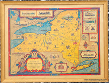
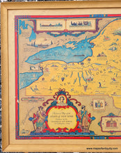
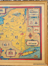
Antique map of New York state, by George Annand, published by the Historical Map Bureau, 1937. This vibrant pictorial map of the state of New York features illustrations throughout of notable buildings, people, pasttimes, and history. This map has been afixed to a board and framed without glass (it should be reframed with UV protective glass). It is in good to very good condition with excellent original color, some small areas with damage to the map surface, and a tear on the right side. Map measures approx. 16.25 x 21.75 inches to the neatline - edge of printed map. Total size with frame is 19.25 x 25.25 inches. **Note: we recommend in-store pick up for framed items. Additional charge to ship a framed item applies- please contact us for a shipping estimate** Can be shipped unframed for lower shipping cost (map price remains the same).

Item Number: NYO1031