1630s
Maker: Tavernier
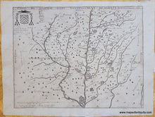
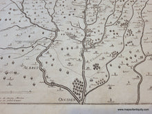
Antique uncolored map of part of France, c. 1630s. This detailed map shows the southwest part of France in the Landes Department. The river at center is the Adour River and includes Aire-sur-l'Adour, Mont-de-Marsan, Saint-Sever, Sault-de-Navailles and more. North is oriented to the left. It includes small villages and towns, as well as some topography pictorially with trees. This rare map bears the name of Jean Boisseau, but we believe this edition may have been published by Tavernier, who is known for publishing atlases with maps from a variety of mapmakers. It is interesting to note the faint guide-lines near the text in the upper and lower left- these lines helped the engraver ensure that the letters were all the correct size and did not slant accidentally, but the guide lines are not supposed to be visible in the finished print. Very good restored condition, map has been cleaned and deacidified. Some minor signs of age remain, including mild stains. Measures approx. 14.5 x 19 inches to the neatline.
Item Number: EUR2892


