Current hours: 10am to 5pm Monday through Saturday. 12pm to 5pm Sundays. We are CLOSED on Christmas Day and New Years Day. We will close early (3pm) on Christmas Eve. IMPORTANT PLEASE NOTE: We have become aware that some of our photos have been stolen by other websites. Our maps are only available at our website www.mapsofantiquity.com or at our store!

Antique-map-The-Provinces-of-New-York-and-New-Jersey-with-part-of-Pensilvania-and-the-Province-of-Quebec-(Upper-Half)-Sayer-Bennett-1775-1776-American-Revolution-1770s-1700s-Colonial-America-Colonies-Maps-of-Antiquity
1775/1776 - The Provinces Of New York And Jersey; With Part Pensilvania The Province Quebec. (Upper
  • Load image into Gallery viewer, Antique-map-The-Provinces-of-New-York-and-New-Jersey-with-part-of-Pensilvania-and-the-Province-of-Quebec-(Upper-Half)-Sayer-Bennett-1775-1776-American-Revolution-1770s-1700s-Colonial-America-Colonies-Maps-of-Antiquity
  • Load image into Gallery viewer, 1775/1776 - The Provinces Of New York And Jersey; With Part Pensilvania The Province Quebec. (Upper
  • Load image into Gallery viewer, 1775/1776 - The Provinces Of New York And Jersey; With Part Pensilvania The Province Quebec. (Upper
  • Load image into Gallery viewer, 1775/1776 - The Provinces Of New York And Jersey; With Part Pensilvania The Province Quebec. (Upper
  • Load image into Gallery viewer, 1775/1776 - The Provinces Of New York And Jersey; With Part Pensilvania The Province Quebec. (Upper

1775/1776 - The Provinces of New York, and New Jersey; with part of Pensilvania, and the Province of Quebec. (Upper Half) - Antique Map

Regular price
$1,200.00
Sale price
$1,200.00
Regular price
Sold out
Unit price
per 
Shipping calculated at checkout.

Item number: USA300
Genuine Antique Hand Colored Map

1775/1776

Maker: Sayer & Bennett.

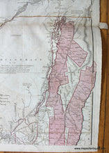
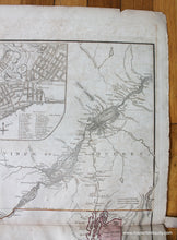
Antique hand colored map of part of colonial America, published by Sayer & Bennett in either 1775 or 1776 (this map was published in various versions in different years and this map is one of the later versions). This is the northern half of the map (we do not have the southern half at this time). The map in its entirety is one of the most important and thorough maps of the region published at the time of the American Revolution. Originally prepared by Holland, who was Surveyor General for the Northern District of North America, as part of a general survey of North America east of the Mississippi to be based upon geodetic principles, on a scale of one inch to one mile in the 1760s. Holland's work was interrupted in 1775 by the start of the American Revolution. The unexplored Adirondack County is left almost entirely blank, with a paragraph of text that begins, "Beaver Hunting Country of the Confederated Indians." Fascinating notations are scattered across the face of the map. Includes three insets: A chart of the mouth of the Hudson River; A plan of the City of New York; Plan of Amboy. Wonderful representations of Lake Champlain, the St Lawrence River, Lake Ontario, and Montreal. Good to very good condition with some light image transfer and some toning/wear at paper edges. Approx. 26 x 20 inches to the neatline. **NOTE- because this map requires extra insurance for shipping, an additional charge will appear on your card after your original purchase. If you would like to know what that charge will be, please contact us.**

Item Number: USA300