Current hours: 10am to 5pm Monday through Saturday. 12pm to 5pm Sundays. We are CLOSED on Christmas Day and New Years Day. We will close early (3pm) on Christmas Eve. IMPORTANT PLEASE NOTE: We have become aware that some of our photos have been stolen by other websites. Our maps are only available at our website www.mapsofantiquity.com or at our store!

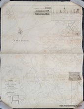
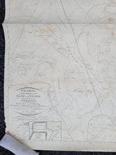
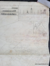
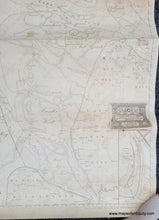
Genuine-Antique-Nautical-Chart-Chart-of-the-mouths-of-the-Elbe-and-Weser-Rivers-with-a-part-of-the-North-Sea---Charte-von-den-Mundungen-der-Elbe-und-Weser-nebst-einem-Theileder-Nordsee-1825-Schiffarts-and-Halfen-Deputation-Maps-Of-Antiquity
  • Load image into Gallery viewer, Genuine-Antique-Nautical-Chart-Chart-of-the-mouths-of-the-Elbe-and-Weser-Rivers-with-a-part-of-the-North-Sea---Charte-von-den-Mundungen-der-Elbe-und-Weser-nebst-einem-Theileder-Nordsee-1825-Schiffarts-and-Halfen-Deputation-Maps-Of-Antiquity
  • Load image into Gallery viewer, Genuine-Antique-Nautical-Chart-Chart-of-the-mouths-of-the-Elbe-and-Weser-Rivers-with-a-part-of-the-North-Sea---Charte-von-den-Mundungen-der-Elbe-und-Weser-nebst-einem-Theileder-Nordsee-1825-Schiffarts-and-Halfen-Deputation-Maps-Of-Antiquity
  • Load image into Gallery viewer, Genuine-Antique-Nautical-Chart-Chart-of-the-mouths-of-the-Elbe-and-Weser-Rivers-with-a-part-of-the-North-Sea---Charte-von-den-Mundungen-der-Elbe-und-Weser-nebst-einem-Theileder-Nordsee-1825-Schiffarts-and-Halfen-Deputation-Maps-Of-Antiquity
  • Load image into Gallery viewer, Genuine-Antique-Nautical-Chart-Chart-of-the-mouths-of-the-Elbe-and-Weser-Rivers-with-a-part-of-the-North-Sea---Charte-von-den-Mundungen-der-Elbe-und-Weser-nebst-einem-Theileder-Nordsee-1825-Schiffarts-and-Halfen-Deputation-Maps-Of-Antiquity

1825 - Chart of the mouths of the Elbe and Weser Rivers, (Germany) with a part of the North Sea - Charte von den Mundungen der Elbe und Weser, nebst einem Theileder Nordsee - Antique Chart

Regular price
$195.00
Sale price
$195.00
Regular price
Sold out
Unit price
per 
Shipping calculated at checkout.

Item number: NAU408
Genuine Antique Nautical Chart

1825

Maker: Schiffarts and Halfen Deputation


Antique nautical blueback chart showing the northwestern coast of Germany at the entrance of the Elba and Weser Rivers. "Published by the Highly Commendable Schiffarts and Halfen Deputation in Hamburg. Compiled and signed under the direction of Director Woltman E.W. Schuback, conductor in 1825." With water depths, inset maps, recognition profiles, lighthouses, and more. This was a working document that aided the navigation of ships in tricky locations and it has the addition of the affixed paper that indicates where it was sold. This chart is in fair condition with obvious stains, a strong horizontal crease, some surface damage, some edge damage, and other signs of age. If you appreciate a chart with character, this is a handsome early chart at a good price. Measures approx. 32 x 25.25 inches to the neatline. 


Item Number: NAU408