Winter hours: Tuesday - Saturday 10am to 5pm. Close Sundays and Mondays until May. We appreciate your business!

Antique-Printed-Color-Map-Portugal-and-Italy-1848-Goodrich-1800s-19th-century-Maps-of-Antiquity
1848 - Italy - Antique Map
  • Load image into Gallery viewer, Antique-Printed-Color-Map-Portugal-and-Italy-1848-Goodrich-1800s-19th-century-Maps-of-Antiquity
  • Load image into Gallery viewer, 1848 - Italy - Antique Map

1848 - Italy - Antique Map

Regular price
$30.00
Sale price
$30.00
Regular price
Sold out
Unit price
per 
Shipping calculated at checkout.

Item number: EUR2472
Genuine Antique Printed Color Map

1848

Maker: Goodrich.

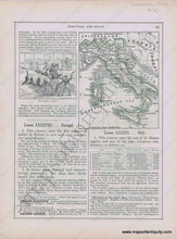
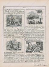
Antique early printed color outlined two-sided page from A National Geography for Schools written by S.G. Goodrich and published by Huntington and Savage in 1848, including engravings of a Bull Fight in Spain, Palace in Venice, View of the Republic of San Marino, A Church in Florence, and Italians, with text and tables describing the region, etc. In very good antique condition with minor toning, foxing and general signs of age, page measures approximately 10.5 x 8.5 inches.

Item Number: EUR2472