c. 1884
Maker: Colby.
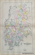
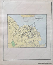
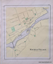
Double-sided sheet of hand-colored antique maps; centerfold map is Hancock County, Maine, with named and unnamed townships, including Amherst, Aurora, Bar Harbor, Blue Hill, Brooklin, Brooksville, Bucksport, Castine, Cranberry Isles, Dedham, Deer Isle, Eastbrook, Ellsworth, Franklin, Frenchboro, Gouldsboro, Great Pond, Hancock, Lamoine, Mariaville, Mount Desert, Orland, Osborn, Otis, Penobscot, Prospect Harbor, Sedgwick, Sorrento, Southwest Harbor, Stonington, Sullivan, Surry, Swan's Island, Tremont, Trenton, Verona, Waltham, and Winter Harbor, also Penobscot Bay, Blue Hill Bay, Frenchman's Bay, the major islands of Mount Desert, Swan's Island, Isle au Haut and many smaller islands. Verso maps are Bar Harbor and Machias Villages showing streets and buildings. Good condition with some separation at both sides of center fold. Centerfold map measures approx. 26 x 15 and smaller maps measure approx. 15 x 12.5 inches.
Item Number: MAI074A


