Winter hours: Tuesday - Saturday 10am to 5pm. Close Sundays and Mondays until May. We appreciate your business!

Genuine-Antique-Map-Bowles-New-Pocket-Map-of-the-Most-Inhabited-Part-of-New-England-1776-Bowles-Maps-Of-Antiquity
close of of Long Island, Manhattan, Connecticut from Genuine-Antique-Map-Bowles-New-Pocket-Map-of-the-Most-Inhabited-Part-of-New-England-1776-Bowles-Maps-Of-Antiquity
close of of Western Massachusetts, Vermont, New York, Connecticut from Genuine-Antique-Map-Bowles-New-Pocket-Map-of-the-Most-Inhabited-Part-of-New-England-1776-Bowles-Maps-Of-Antiquity
close up of New York Upstate, Vermont, Western Massachusetts, New Hampshire from Genuine-Antique-Map-Bowles-New-Pocket-Map-of-the-Most-Inhabited-Part-of-New-England-1776-Bowles-Maps-Of-Antiquity
close up of Southern Maine, Vermont, Northern Massachusetts, New Hampshire from Genuine-Antique-Map-Bowles-New-Pocket-Map-of-the-Most-Inhabited-Part-of-New-England-1776-Bowles-Maps-Of-Antiquity
close up of Rhode Island, Massachusetts, New Hampshire from Genuine-Antique-Map-Bowles-New-Pocket-Map-of-the-Most-Inhabited-Part-of-New-England-1776-Bowles-Maps-Of-Antiquity
close up of Southern Massachusetts, Rhode Island, and Boston Inset from Genuine-Antique-Map-Bowles-New-Pocket-Map-of-the-Most-Inhabited-Part-of-New-England-1776-Bowles-Maps-Of-Antiquity
close up of Cape Cod, Southern Massachusetts, and Boston Inset from Genuine-Antique-Map-Bowles-New-Pocket-Map-of-the-Most-Inhabited-Part-of-New-England-1776-Bowles-Maps-Of-Antiquity
close up of Cape Cod, Massachusetts, Title of the map, and New Hampshire and Maine from Genuine-Antique-Map-Bowles-New-Pocket-Map-of-the-Most-Inhabited-Part-of-New-England-1776-Bowles-Maps-Of-Antiquity
close up of Cape Ann, Southern Maine, New Hampshire from Genuine-Antique-Map-Bowles-New-Pocket-Map-of-the-Most-Inhabited-Part-of-New-England-1776-Bowles-Maps-Of-Antiquity
  • Load image into Gallery viewer, Genuine-Antique-Map-Bowles-New-Pocket-Map-of-the-Most-Inhabited-Part-of-New-England-1776-Bowles-Maps-Of-Antiquity
  • Load image into Gallery viewer, close of of Long Island, Manhattan, Connecticut from Genuine-Antique-Map-Bowles-New-Pocket-Map-of-the-Most-Inhabited-Part-of-New-England-1776-Bowles-Maps-Of-Antiquity
  • Load image into Gallery viewer, close of of Western Massachusetts, Vermont, New York, Connecticut from Genuine-Antique-Map-Bowles-New-Pocket-Map-of-the-Most-Inhabited-Part-of-New-England-1776-Bowles-Maps-Of-Antiquity
  • Load image into Gallery viewer, close up of New York Upstate, Vermont, Western Massachusetts, New Hampshire from Genuine-Antique-Map-Bowles-New-Pocket-Map-of-the-Most-Inhabited-Part-of-New-England-1776-Bowles-Maps-Of-Antiquity
  • Load image into Gallery viewer, close up of Southern Maine, Vermont, Northern Massachusetts, New Hampshire from Genuine-Antique-Map-Bowles-New-Pocket-Map-of-the-Most-Inhabited-Part-of-New-England-1776-Bowles-Maps-Of-Antiquity
  • Load image into Gallery viewer, close up of Rhode Island, Massachusetts, New Hampshire from Genuine-Antique-Map-Bowles-New-Pocket-Map-of-the-Most-Inhabited-Part-of-New-England-1776-Bowles-Maps-Of-Antiquity
  • Load image into Gallery viewer, close up of Southern Massachusetts, Rhode Island, and Boston Inset from Genuine-Antique-Map-Bowles-New-Pocket-Map-of-the-Most-Inhabited-Part-of-New-England-1776-Bowles-Maps-Of-Antiquity
  • Load image into Gallery viewer, close up of Cape Cod, Southern Massachusetts, and Boston Inset from Genuine-Antique-Map-Bowles-New-Pocket-Map-of-the-Most-Inhabited-Part-of-New-England-1776-Bowles-Maps-Of-Antiquity
  • Load image into Gallery viewer, close up of Cape Cod, Massachusetts, Title of the map, and New Hampshire and Maine from Genuine-Antique-Map-Bowles-New-Pocket-Map-of-the-Most-Inhabited-Part-of-New-England-1776-Bowles-Maps-Of-Antiquity
  • Load image into Gallery viewer, close up of Cape Ann, Southern Maine, New Hampshire from Genuine-Antique-Map-Bowles-New-Pocket-Map-of-the-Most-Inhabited-Part-of-New-England-1776-Bowles-Maps-Of-Antiquity

1776 - Bowles' New Pocket Map of the Most Inhabited Part of New England - Antique Map

Regular price
$8,750.00
Sale price
$8,750.00
Regular price
Sold out
Unit price
per 
Shipping calculated at checkout.

Item number: CSMT144
Genuine Antique Map

1776

Maker: Bowles


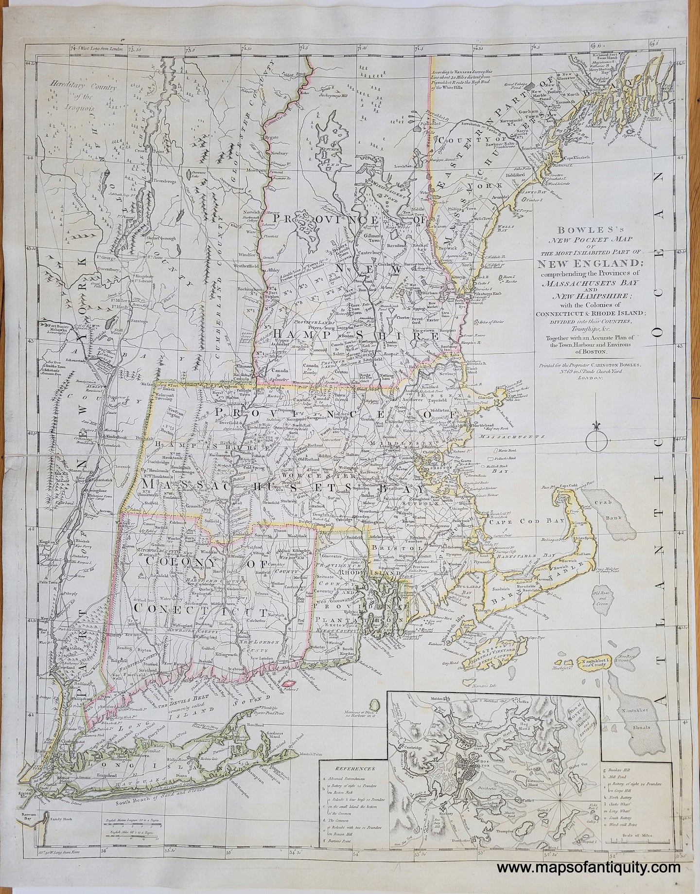
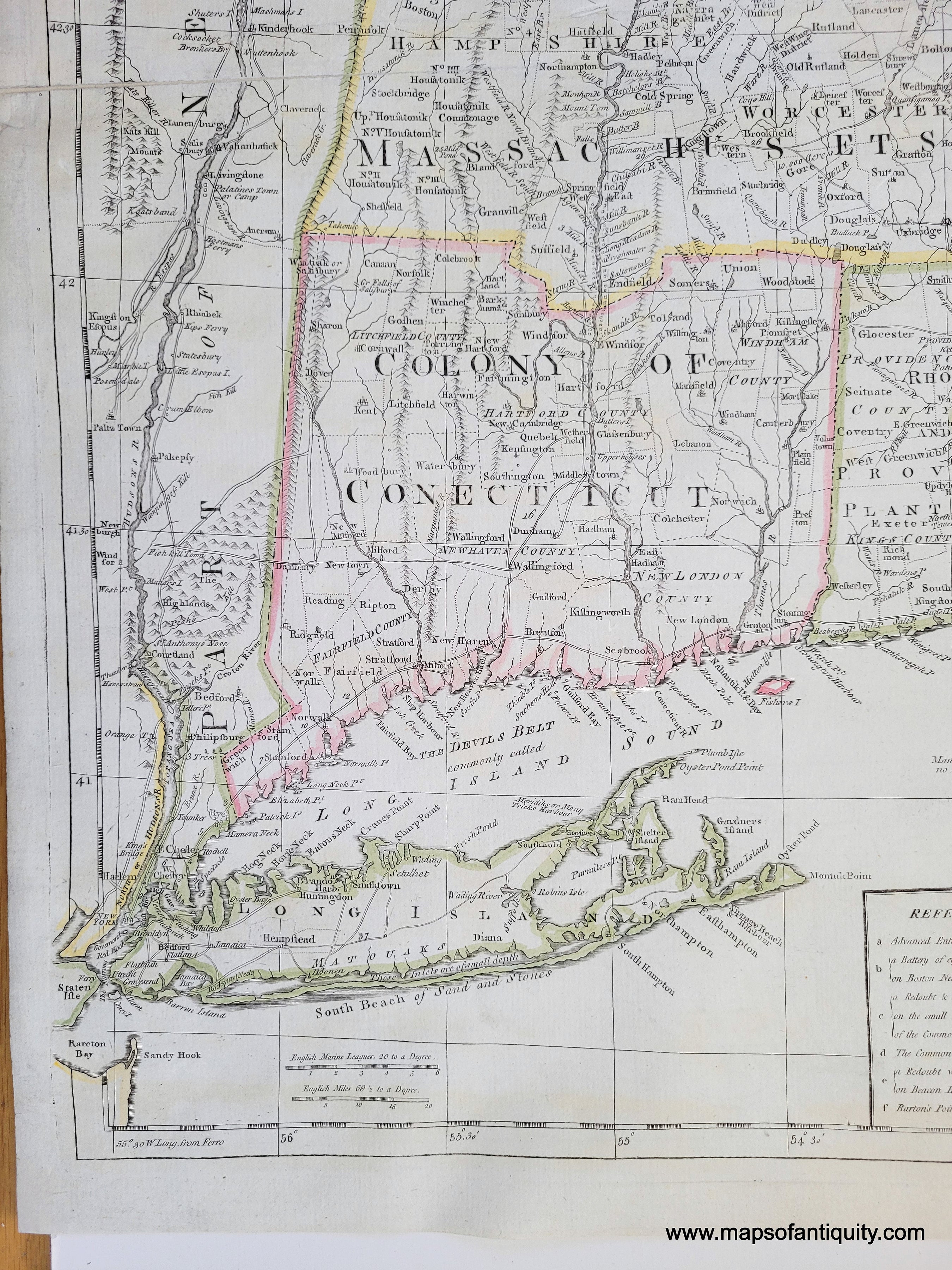
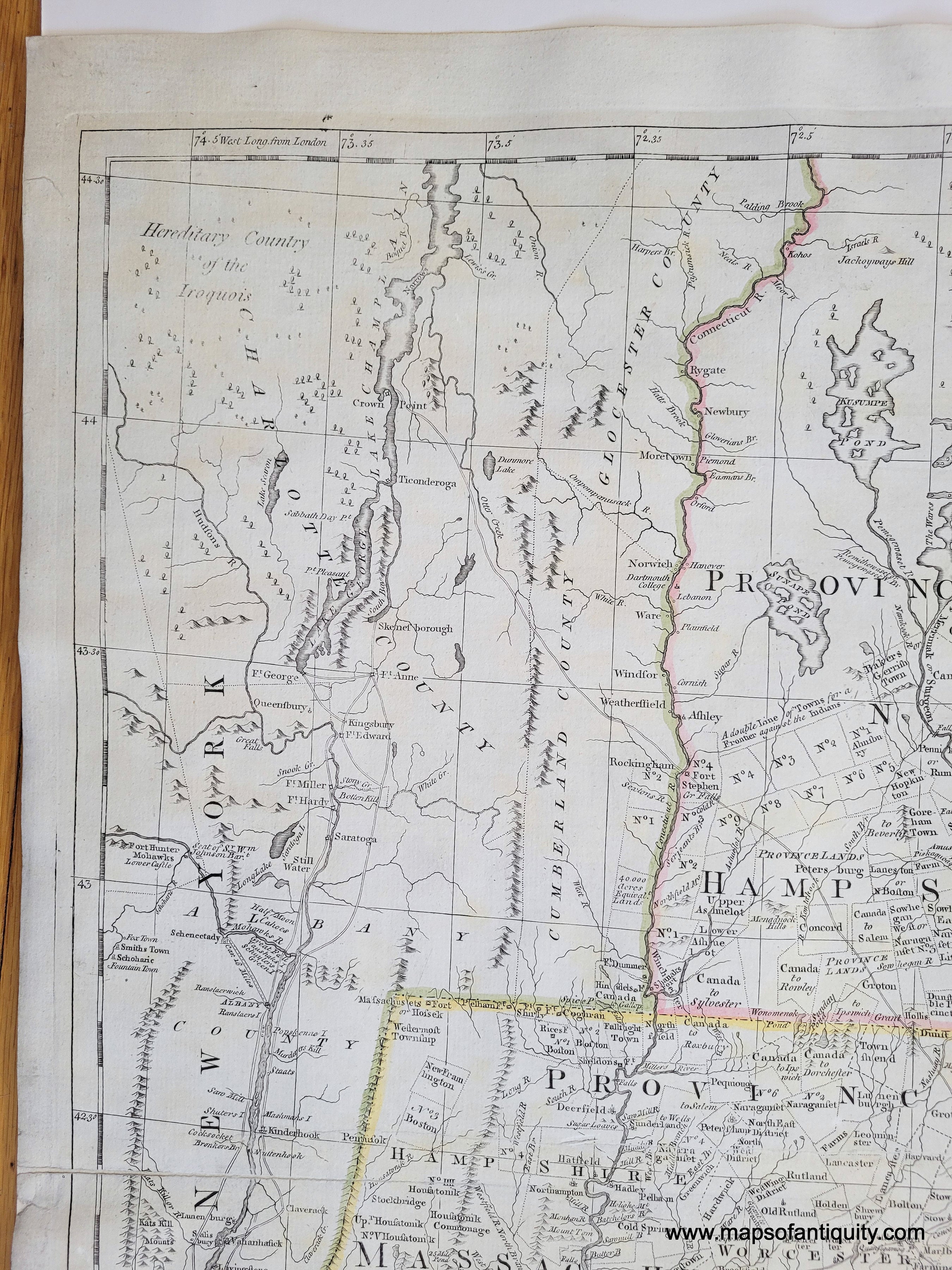
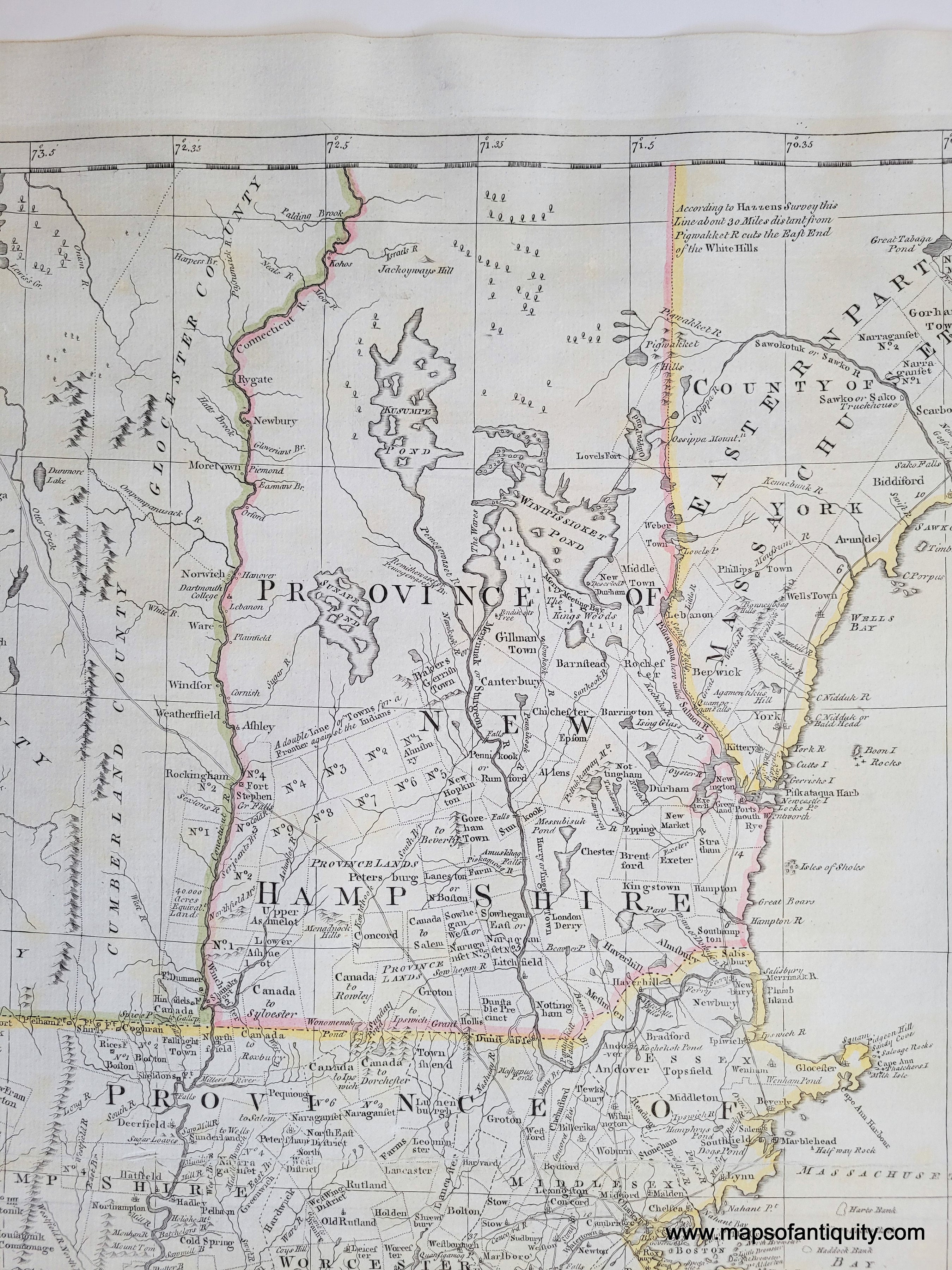
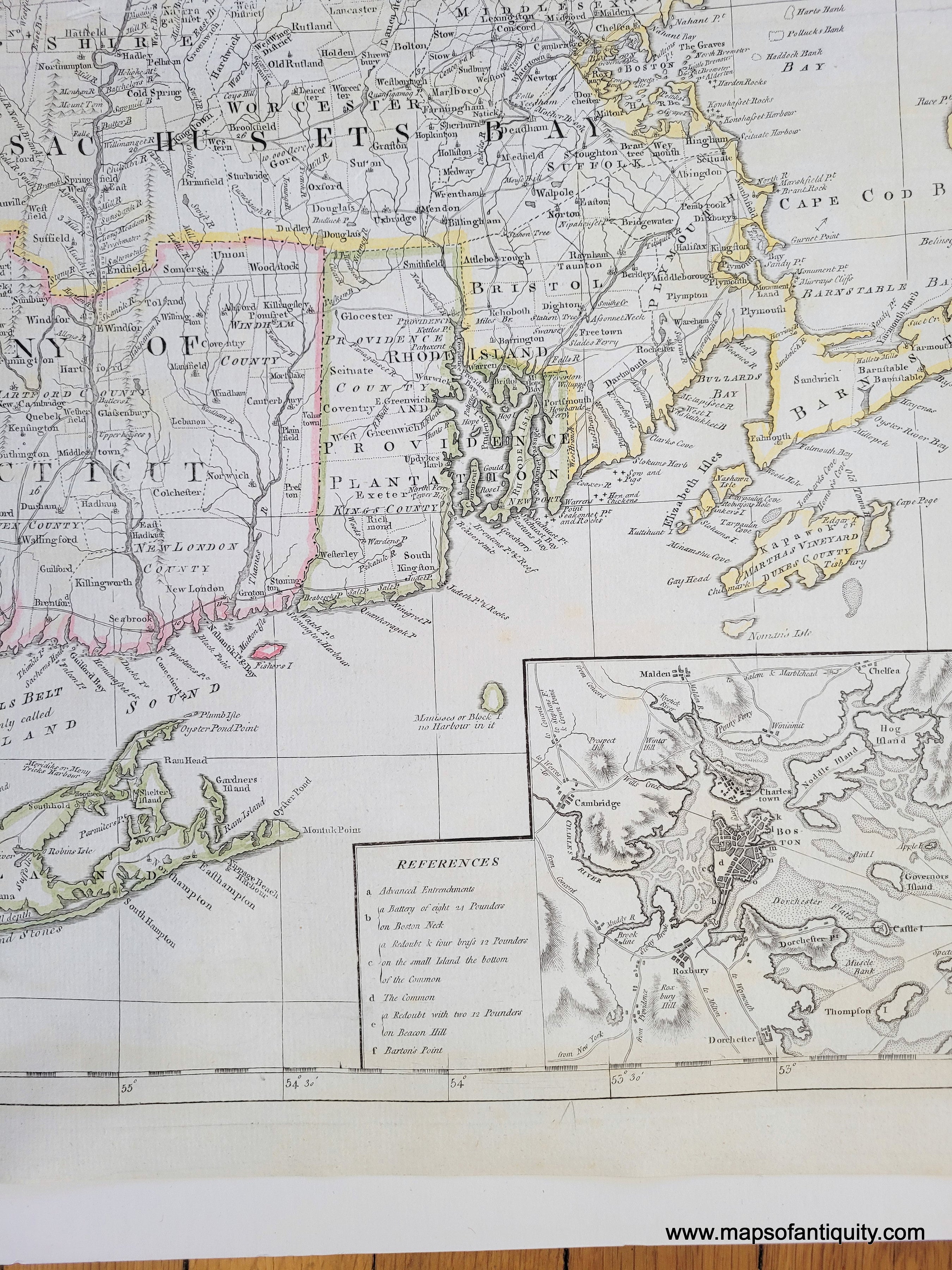
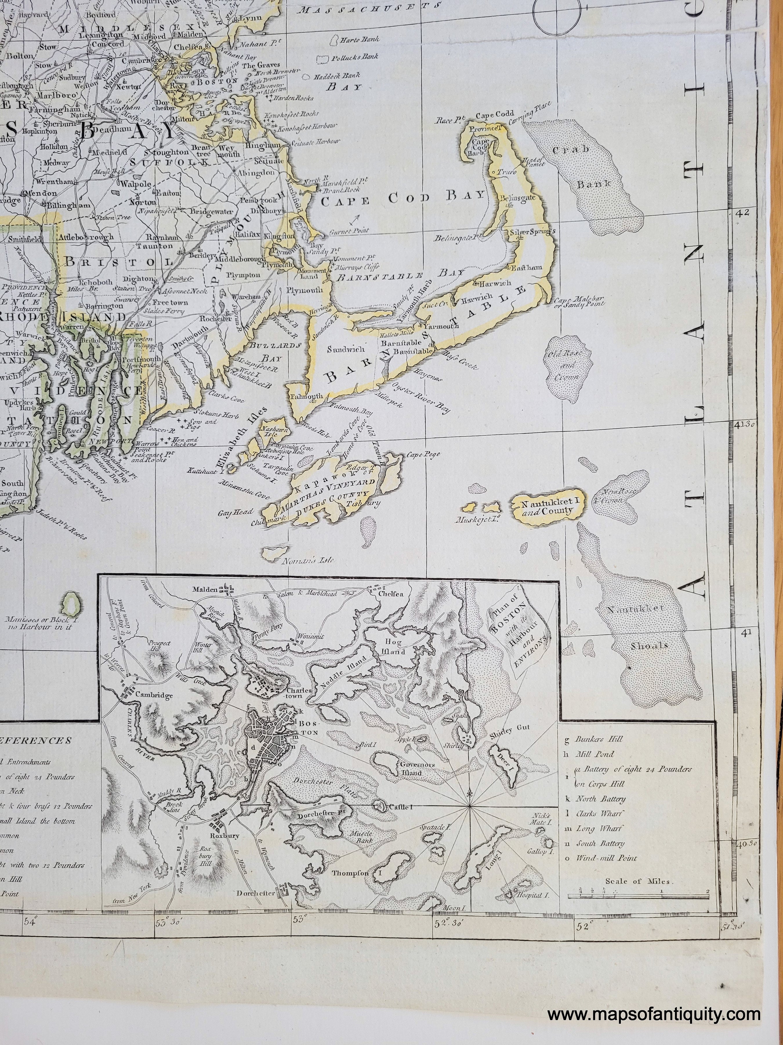
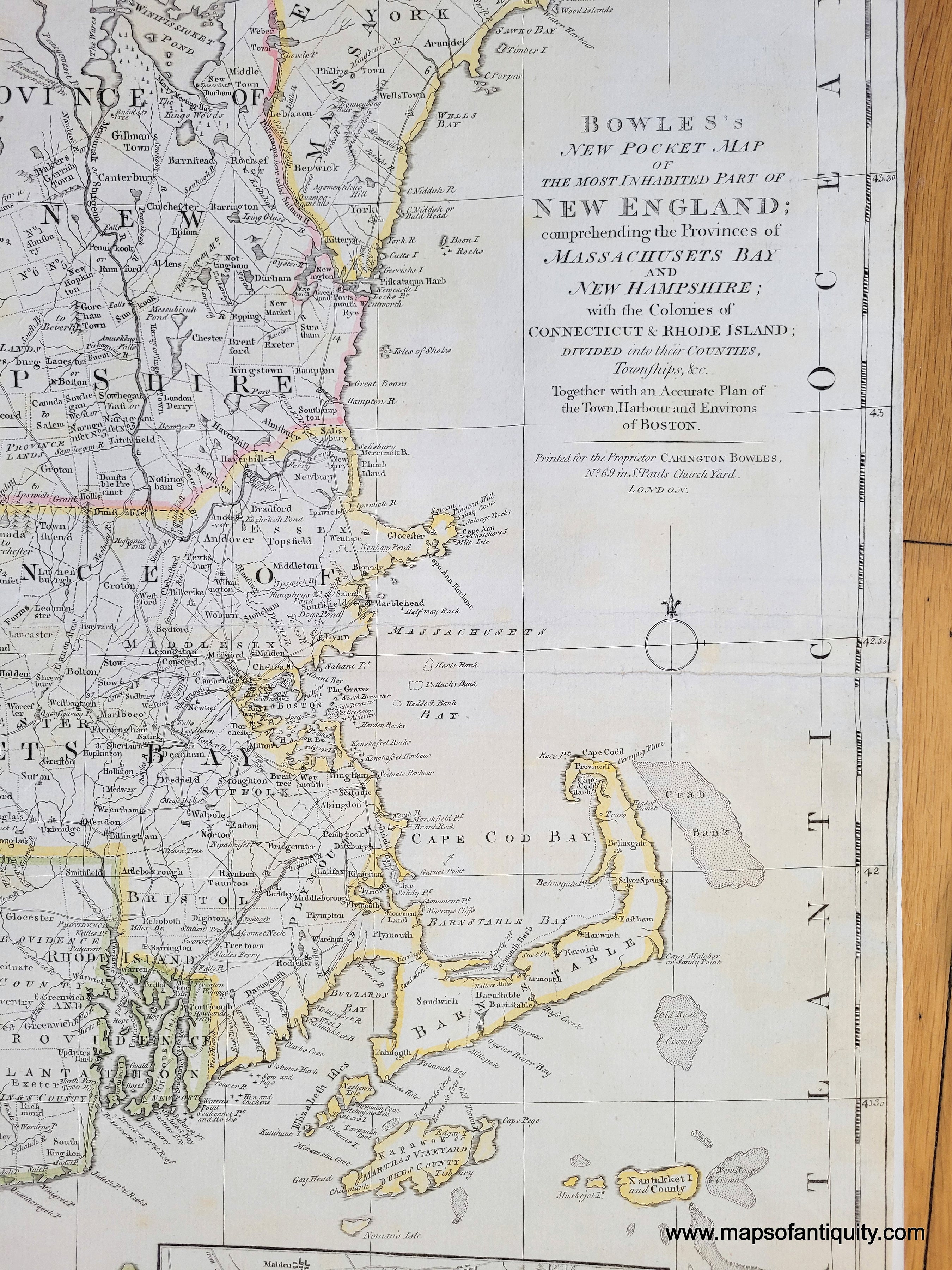
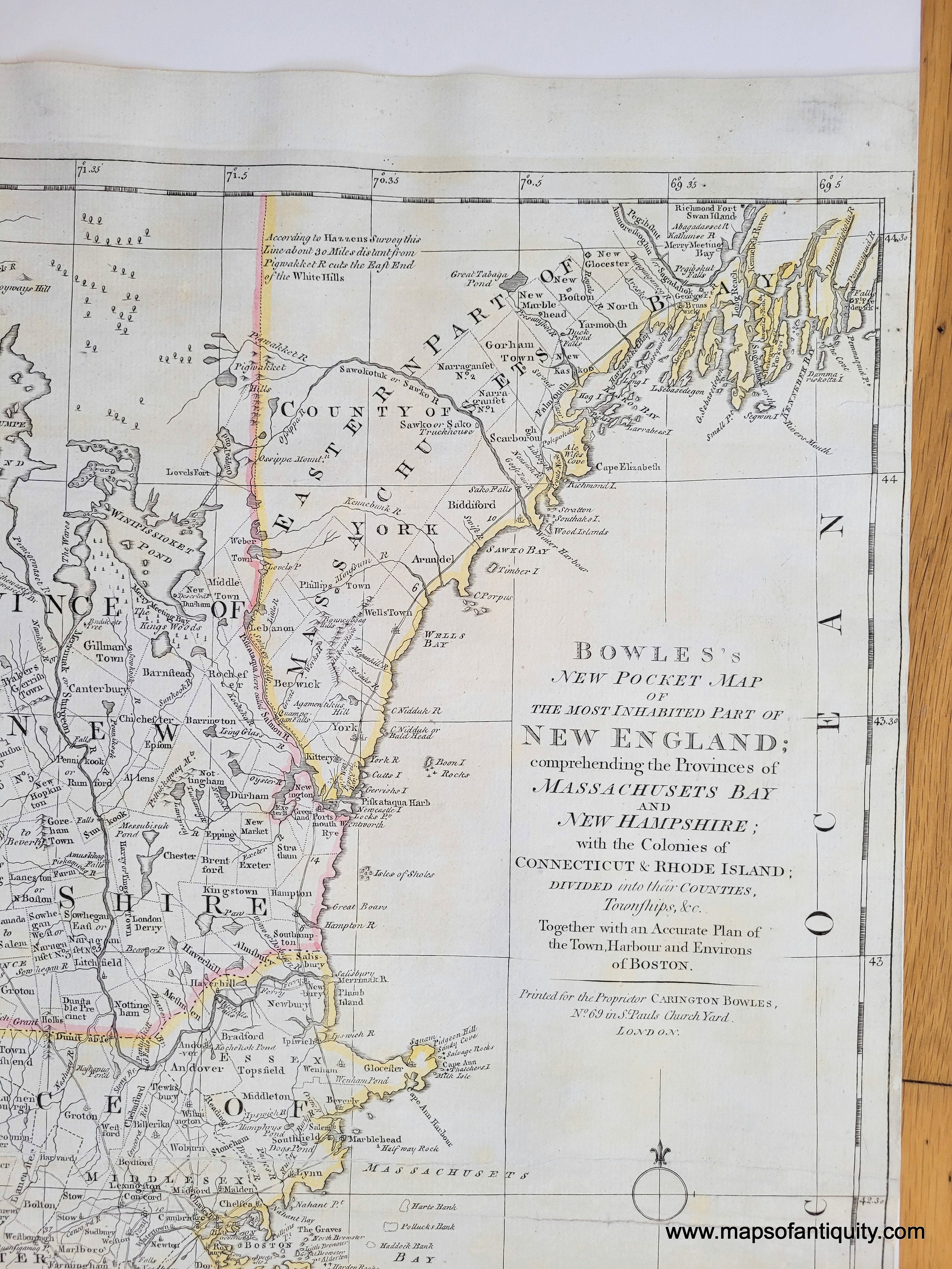
Well-known and highly collectible antique map of New England, by Carington Bowles, 1776 (circa). Notable details on this map: An inset of Boston shows Bunker Hill and the locations of batteries, entrenchments, and redoubts relating to the recent activity around Boston during the Revolutionary War; at the time of publication Vermont was still officially part of New York but also claimed by New Hampshire- Vermont was granted statehood in 1791; Maine was part of Massachusetts at this time and is labelled "Eastern Part of Massachusetts"; Nantucket, Martha's Vineyard, and Block Island all have interesting inaccurate shapes. The map itself also has notable updates relating to the revolution from previous maps, including the roads connecting Concord and Boston and the placement of towns central to the conflict, such as Lexington, Concord, and Cambridge, to give them more prominence. For the first time, the road system of New England can be seen as well as the borders of cities, towns, and colonies. In this regard, the map is an important record of the history of the evolving borders between the colonies, later states, and provides alternative borders in disputed areas. Dartmouth College is shown for the first time on this state of the map. The rivers are fairly well done yet the mountains are depicted in an older style without much detail. The large lakes are shown, including Lake George, Lake Champlain, and Lake Winnipesaukee. A fascinating and important historical map. Very good restored condition; this map has been cleaned, deacidified, and backed on light-weight paper for stability. It maintains some minor signs of age including slight stains, tight margins on right side, slight waviness to the paper at top and bottom, repaired tears along center fold. Measures approx. 25.25 x 20.5 inches to the neatline.
Full title: Bowles's new pocket map of the most inhabited part of New England : comprehending the provinces of Massachusets Bay and New Hampshire; with the colonies of Connecticut & Rhode Island; divided into their counties, townships, &c. together with an accurate plan of the town, harbour and environs of Boston


Item Number: CSMT144