Current hours: 10:30am to 5pm Tuesday through Saturday. We are closed Sundays and Mondays for the Winter. IMPORTANT PLEASE NOTE: We have become aware that some of our photos have been stolen by other websites. Our maps are only available at our website www.mapsofantiquity.com or at our store!

Genuine-Antique-Wall-Map-Map-of-Massachusetts-Rhode-Island-Connecticut-compiled-from-the-Latest-Authorities-1852-Ensign-Thayer-Maps-Of-Antiquity
  • Load image into Gallery viewer, Genuine-Antique-Wall-Map-Map-of-Massachusetts-Rhode-Island-Connecticut-compiled-from-the-Latest-Authorities-1852-Ensign-Thayer-Maps-Of-Antiquity
  • Load image into Gallery viewer, Genuine-Antique-Wall-Map-Map-of-Massachusetts-Rhode-Island-Connecticut-compiled-from-the-Latest-Authorities-1852-Ensign-Thayer-Maps-Of-Antiquity
  • Load image into Gallery viewer, Genuine-Antique-Wall-Map-Map-of-Massachusetts-Rhode-Island-Connecticut-compiled-from-the-Latest-Authorities-1852-Ensign-Thayer-Maps-Of-Antiquity

1852 - Map of Massachusetts, Rhode Island & Connecticut compiled from the Latest Authorities - Antique Map

Regular price
$1,800.00
Sale price
$1,800.00
Regular price
Sold out
Unit price
per 
Shipping calculated at checkout.

Item number: NEW200
Genuine Antique Wall Map

1852

Maker: Ensign & Thayer

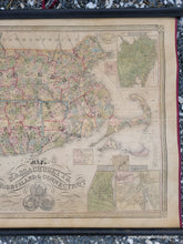
Antique wall map of Southern New England by Ensign & Thayer, 1852. This handsome wall map on wooden rods shows the states of Massachusetts, Rhode Island, and Connecticut, with a bit of New York City, colored by town, with brighter border colors indicating county and state boundaries. Shows roads, railroads, churches, and more. This map has fourteen inset maps of the cities of Boston, Providence, New York, Salem, New Haven, Hartford, Lowell, New Haven, and several more manufacturing cities. A reference key is on the right side. The state seals for the states are under the title. Decorative border and bound on the sides with a burgundy silk ribbon. Very good restored condition, this map has been cleaned, repaired, and backed on sturdy linen. It retains some signs of age including closed tears and mild toning and spots. Measures approx. 25.5 x 33.5 inches to the neatline or 29.5 x 43 inches total including the rods.

Item Number: NEW200