Winter hours: Tuesday - Saturday 10am to 5pm. Close Sundays and Mondays until May. We appreciate your business!

Antique-Printed-Color-Map-State-of-Massachusetts-Plan-of-the-City-of-Boston;-Verso-View-of-Boston-Common-Bunker-Hill-Monument-View-of-the-Valley-of-Connecticut-River-from-Mount-Holyoke-1848-Goodrich-Boston-1800s-19th-century-Maps-of-Antiquity
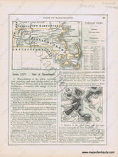
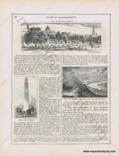
1848 - State of Massachusetts, Plan of the City of Boston; Verso View of Boston Common, Bunker Hill Monument, View of the Valley of Connecticut River from Mount Holyoke - Antique Map
  • Load image into Gallery viewer, Antique-Printed-Color-Map-State-of-Massachusetts-Plan-of-the-City-of-Boston;-Verso-View-of-Boston-Common-Bunker-Hill-Monument-View-of-the-Valley-of-Connecticut-River-from-Mount-Holyoke-1848-Goodrich-Boston-1800s-19th-century-Maps-of-Antiquity
  • Load image into Gallery viewer, 1848 - State of Massachusetts, Plan of the City of Boston; Verso View of Boston Common, Bunker Hill Monument, View of the Valley of Connecticut River from Mount Holyoke - Antique Map

1848 - State of Massachusetts, Plan of the City of Boston; Verso View of Boston Common, Bunker Hill Monument, View of the Valley of Connecticut River from Mount Holyoke - Antique Map

Regular price
$40.00
Sale price
$40.00
Regular price
Sold out
Unit price
per 
Shipping calculated at checkout.

Item number: MAS2046
Genuine Antique Printed Color Map

1848

Maker: Goodrich.

Antique early printed color outlined two-sided page from A National Geography for Schools written by S.G. Goodrich and published by Huntington and Savage in 1848, with text and engravings describing the region, etc. In very good antique condition with minor toning, foxing and general signs of age, page measures approximately 10.5 x 8.5 inches.

Item Number: MAS2046