Current hours: 10am to 5pm Monday through Saturday. Closed on Sundays. PLEASE NOTE: Our maps are only available at our website www.mapsofantiquity.com or at our store!

Antique-Black-and-White-Nautical-Chart-West-Coast-of-North-America-from-San-Blas-to-San-Francisco-1887-Imray-&-Son-US-West-Charts-Mexico-Charts-1800s-19th-century-Maps-of-Antiquity
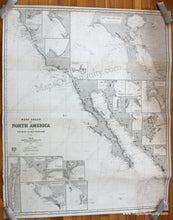
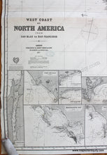
1887 / 1888 - West Coast of North America from San Blas to San Francisco - Antique Chart
  • Load image into Gallery viewer, Antique-Black-and-White-Nautical-Chart-West-Coast-of-North-America-from-San-Blas-to-San-Francisco-1887-Imray-&-Son-US-West-Charts-Mexico-Charts-1800s-19th-century-Maps-of-Antiquity
  • Load image into Gallery viewer, 1887 / 1888 - West Coast of North America from San Blas to San Francisco - Antique Chart
  • Load image into Gallery viewer, 1887 / 1888 - West Coast of North America from San Blas to San Francisco - Antique Chart
  • Load image into Gallery viewer, 1887 / 1888 - West Coast of North America from San Blas to San Francisco - Antique Chart

1887 / 1888 - West Coast of North America from San Blas to San Francisco - Antique Chart

Regular price
$1,400.00
Sale price
$1,400.00
Regular price
Sold out
Unit price
per 
Shipping calculated at checkout.

Item number: NAU356
Genuine Antique Nautical Chart

1887 / 1888

Maker: Imray & Son.

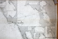
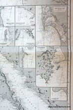
Antique uncolored nautical chart showing the California's coast and part of the western coast of Mexico, including present-day Baja California. This chart was published in 1887 and corrected to 1888. Map includes 21 inset maps showing regional bays, islands, and coastal cities (Santa Barbara, Bodega Bay, Monterey, South Farallon Islands, San Diego Bay, Guaymas, Port San Blas, San Jose del Cabo Bay, Tomales Bay, Magdalena Bay, etc.), the largest of these is a map of San Francisco Bay. This chart has been rebacked, and is in very good overall antique condition- there is a darker section in the lower right corner that is a hand-drawn patch (that section must have been damaged or removed at some point and someone created this patch to fill in the missing portion- it is nicely done and only noticeable when examined closely) and a soft horizontal fold near the center. The edges have some wear and the chart will benefit from laying flat before being framed. Chart measures approximately 48.5" x 40" (H x W) to the neatline. **NOTE- because this map requires extra insurance for shipping, an additional charge will appear on your card after your original purchase. If you would like to know what that charge will be, please contact us.**

Item Number: NAU356