Current hours: 10am to 5pm Monday through Saturday. 12pm to 5pm Sundays. We are CLOSED on Christmas Day and New Years Day. We will close early (3pm) on Christmas Eve. IMPORTANT PLEASE NOTE: We have become aware that some of our photos have been stolen by other websites. Our maps are only available at our website www.mapsofantiquity.com or at our store!

Antique-Uncolored-Railroad-Map-Map-of-the-Mexican-National-Railroad-and-its-Connections-verso:-Map-of-the-Milwaukee-Lake-Shore-&-Western-Railway-&-Connections-1889-Railroad-Stock-and-Bonds-Magazine-Midwest-1800s-19th-century-Maps-of-Antiquity
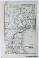
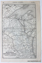
1889 - Map Of The Mexican National Railroad And Its Connections Verso: Milwaukee Lake Shore &
  • Load image into Gallery viewer, Antique-Uncolored-Railroad-Map-Map-of-the-Mexican-National-Railroad-and-its-Connections-verso:-Map-of-the-Milwaukee-Lake-Shore-&-Western-Railway-&-Connections-1889-Railroad-Stock-and-Bonds-Magazine-Midwest-1800s-19th-century-Maps-of-Antiquity
  • Load image into Gallery viewer, 1889 - Map Of The Mexican National Railroad And Its Connections Verso: Milwaukee Lake Shore &

1889 - Map of the Mexican National Railroad and its Connections, verso: Map of the Milwaukee, Lake Shore & Western Railway & Connections - Antique Map

Regular price
$95.00
Sale price
$95.00
Regular price
Sold out
Unit price
per 
Shipping calculated at checkout.

Item number: NAM254
Genuine Antique Uncolored Railroad Map

1889

Maker: Railroad Stock and Bonds Magazine.

Antique railroad map of Texas, part of Mexico and parts of nearby states, showing the Mexican National Railroad running from Vera Cruz through Mexico City and up to Corpus Christi. Also includes many other railroad routes in the area with their stops at many well known cities such as Houston, Austin, Dallas, Fort Worth, Waco, San Antonio, and more. Published in the 1889 Railroad Stocks and Bonds Investor's Supplement. Verso map of the Michigan and Wisconsin area showing railroads from Milwaukee to Ashland and other points. Very good condition with a few minor spots and a smudging of the ink on the right border line of the Texas map (map is otherwise perfectly clear). Approx. 12.5 x 8.5 inches to the paper edges.

Item Number: NAM254