Pickup available at 1409 MAIN ST, CHATHAM MA
Usually ready in 24 hours
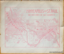
1892 - Minneapolis and St. Paul. - The Twin Cities of the Northwest. - Antique Map
-
1409 MAIN ST, CHATHAM MA
Pickup available, usually ready in 24 hours1409 Main Street
Chatham MA 02633
United States+15089451660
1892
Maker: Hunt & Eaton.
Antique printed color map of Minneapolis and St. Paul, Minnesota, by Hunt and Eaton, 1892. Shows a general overview of the city blocks of both cities, railroads, bodies of water, and a couple points of interest (Fort Snelling, State Agricultural Society, etc.) Fair to good overall antique condition with mild toning throughout and some wear and tears at the paper edges. Measures approximately 9" x 12" (H x W) to the neatline. Priced as-is.
Item Number: TOW477


