Winter hours: Tuesday - Saturday 10am to 5pm. Close Sundays and Mondays until May. We appreciate your business!

Antique-Printed-Color-Map-Minneapolis-verso:-Official-Map-of-The-City-of-Duluth.-North-America-Midwest-1900-Cram-Maps-Of-Antiquity
  • Load image into Gallery viewer, Antique-Printed-Color-Map-Minneapolis-verso:-Official-Map-of-The-City-of-Duluth.-North-America-Midwest-1900-Cram-Maps-Of-Antiquity
  • Load image into Gallery viewer, Antique-Printed-Color-Map-Minneapolis-verso:-Official-Map-of-The-City-of-Duluth.-North-America-Midwest-1900-Cram-Maps-Of-Antiquity

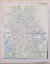
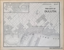
1900 - Minneapolis, verso: Official Map of The City of Duluth. - Antique Map

Regular price
$50.00
Sale price
$50.00
Regular price
Sold out
Unit price
per 
Shipping calculated at checkout.

Item number: MWE284
Genuine Antique Printed Color Map

1900

Maker: Cram.


Antique printed color map of the city of Minneapolis, Minnesota (Recto.) Includes indications for "steam railroads" and "horse railroads." Verso: A map of the city of Duluth, Minnesota. Verso map is in black and white. Includes two inset maps to show the farthest extents of the city. Very good condition with some slight overall toning of the page. By Cram, in Cram's Universal Atlas Geographical, Astronomical and Historical, 1900. Recto map (Minneapolis, MN) measures approximately 12.5" x 9.75" to the neatline. Verso map (Duluth, MN) measures approx. 10" x 12.75" to the neatline. 


Item Number: MWE284