Winter hours: Tuesday - Saturday 10am to 5pm. Close Sundays and Mondays until May. We appreciate your business!

Genuine-Antique-Chart-A-New-Chart-of-the-Windward-Passages-Containing-the-Islands-of-Jamaica-St-Domingo-with-Part-of-Cuba--1836-Norie-Maps-Of-Antiquity
1836 - A New Chart of the Windward Passages Containing the Islands of Jamaica, St. Domingo, with Part of Cuba, &c. - Antique Map
  • Load image into Gallery viewer, Genuine-Antique-Chart-A-New-Chart-of-the-Windward-Passages-Containing-the-Islands-of-Jamaica-St-Domingo-with-Part-of-Cuba--1836-Norie-Maps-Of-Antiquity
  • Load image into Gallery viewer, 1836 - A New Chart of the Windward Passages Containing the Islands of Jamaica, St. Domingo, with Part of Cuba, &c. - Antique Map
  • Load image into Gallery viewer, 1836 - A New Chart of the Windward Passages Containing the Islands of Jamaica, St. Domingo, with Part of Cuba, &c. - Antique Map
  • Load image into Gallery viewer, 1836 - A New Chart of the Windward Passages Containing the Islands of Jamaica, St. Domingo, with Part of Cuba, &c. - Antique Map
  • Load image into Gallery viewer, 1836 - A New Chart of the Windward Passages Containing the Islands of Jamaica, St. Domingo, with Part of Cuba, &c. - Antique Map
  • Load image into Gallery viewer, 1836 - A New Chart of the Windward Passages Containing the Islands of Jamaica, St. Domingo, with Part of Cuba, &c. - Antique Map
  • Load image into Gallery viewer, 1836 - A New Chart of the Windward Passages Containing the Islands of Jamaica, St. Domingo, with Part of Cuba, &c. - Antique Map
  • Load image into Gallery viewer, 1836 - A New Chart of the Windward Passages Containing the Islands of Jamaica, St. Domingo, with Part of Cuba, &c. - Antique Map
  • Load image into Gallery viewer, 1836 - A New Chart of the Windward Passages Containing the Islands of Jamaica, St. Domingo, with Part of Cuba, &c. - Antique Map
  • Load image into Gallery viewer, 1836 - A New Chart of the Windward Passages Containing the Islands of Jamaica, St. Domingo, with Part of Cuba, &c. - Antique Map
  • Load image into Gallery viewer, 1836 - A New Chart of the Windward Passages Containing the Islands of Jamaica, St. Domingo, with Part of Cuba, &c. - Antique Map

1836 - A New Chart of the Windward Passages Containing the Islands of Jamaica, St. Domingo, with Part of Cuba, &c. - Antique Map

Regular price
$3,800.00
Sale price
$3,800.00
Regular price
Sold out
Unit price
per 
Shipping calculated at checkout.

Item number: CSMT127
Genuine Antique Chart

1836

Maker: Norie

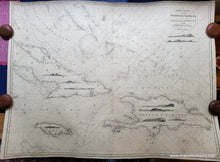
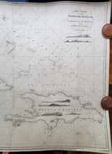
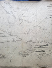
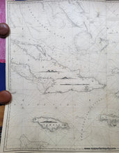
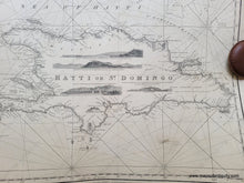
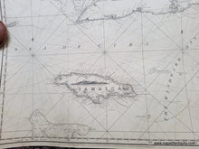
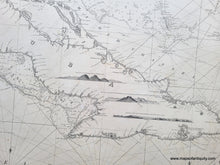
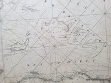
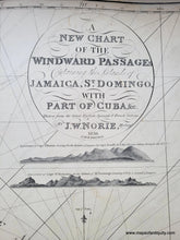
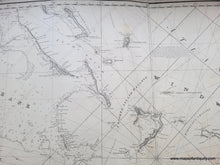
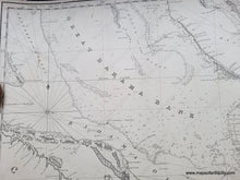
Exquisite antique blueback nautical chart of part of the Caribbean, published by J.W. Norie in 1836. This chart includes the east part of Cuba, Jamaica, part of the Bahamas, Turks and Caicos Islands, Haiti, and Dominican Republic. It shows all of the banks and areas with shallower water including water depths, rhumb lines, and eleven compass roses. This chart also boasts eleven handsomely detailed recognition profiles which helped mariners recognize the coastline from the sea. The land areas include some topography. Very good restored condition. This chart has been professionally cleaned, rebacked with blue paper. It retains some signs of age, including minor stains, wrinkles, and repaired tears. Measures approx. 37 x 49 inches to the neatline. **NOTE- because this map requires extra insurance for shipping, which is why the shipping cost is higher than other items. If you would like it shipped without insurance, please contact us.**

Item Number: CSMT127