Winter hours: Tuesday - Saturday 10am to 5pm. Close Sundays and Mondays until May. We appreciate your business!

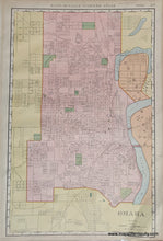
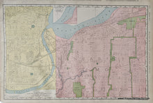
Genuine Antique Printed Color Map-Omaha, verso: Kansas City-1908-Rand-McNally-Maps-Of-Antiquity-1900s-20th-century
  • Load image into Gallery viewer, Genuine Antique Printed Color Map-Omaha, verso: Kansas City-1908-Rand-McNally-Maps-Of-Antiquity-1900s-20th-century
  • Load image into Gallery viewer, Genuine Antique Printed Color Map-Omaha, verso: Kansas City-1908-Rand-McNally-Maps-Of-Antiquity-1900s-20th-century

1908 - Omaha, verso: Kansas City - Antique Map

Regular price
$40.00
Sale price
$40.00
Regular price
Sold out
Unit price
per 
Shipping calculated at checkout.

Item number: MWE506
Genuine Antique Printed Color Map

1908

Maker: Rand-McNally

Antique double-sided printed color map from the Rand-McNally Indexed Atlas, 1908. One side is a map of Omaha Nebraska, NE, and the other side is a map if Kansas City, Missouri MO and Kansas City Kansas KS. Each map includes city blocks, names of major roads, railroad lines, and some points of interest. Good overall antique condition with some toning and small tears at the paper edges. Measures approximately 19" x 12.25" to the neatline.

Item Number: MWE506