Current hours: 10am to 5pm Monday through Saturday. 12pm to 5pm Sundays. IMPORTANT PLEASE NOTE: We have become aware that some of our photos have been stolen by other websites. Our maps are only available at our website www.mapsofantiquity.com or at our store!

Antique-Map-State-United-States-U.S.-West-New-Mexico-Colorado-Home-Library-and-Supply-Association-Pacific-Coast-1892-1890s-1800s-Late-19th-Century-Maps-of-Antiquity-
1892 - New Mexico, Verso: Colorado - Antique Map
  • Load image into Gallery viewer, Antique-Map-State-United-States-U.S.-West-New-Mexico-Colorado-Home-Library-and-Supply-Association-Pacific-Coast-1892-1890s-1800s-Late-19th-Century-Maps-of-Antiquity-
  • Load image into Gallery viewer, 1892 - New Mexico, Verso: Colorado - Antique Map

1892 - New Mexico, Verso: Colorado - Antique Map

Regular price
$85.00
Sale price
$85.00
Regular price
Sold out
Unit price
per 
Shipping calculated at checkout.

Item number: WES299
Genuine Antique Printed Color Map

1892

Maker: Home Library & Supply Association.

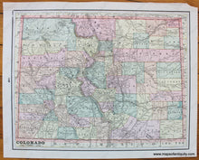
Antique printed color map of New Mexico (Recto.) On verso, a map of Colorado. Both maps are colored by county and include railroads, bodies of water, topographical detail, Indian Reservations, and names of major towns/cities. Published in "The Pacific Coast and the World" by the Home Library and Supply Association, 1892. Very good overall antique condition with some minor paper loss in one corner. Recto map (New Mexico) measures approximately 12" x 9.75" (H x W) to the neatline. Verso map (Colorado) measures approx. 10.25" x 13" to the neatline.

Item Number: WES299