Current hours: 10am to 5pm Monday through Saturday. 12pm to 5pm Sundays. IMPORTANT PLEASE NOTE: We have become aware that some of our photos have been stolen by other websites. Our maps are only available at our website www.mapsofantiquity.com or at our store!

Antique-Hand-Colored-Map-Map-of-New-York-and-Vicinity-United-States-Northeast-1867-Beers-Maps-Of-Antiquity
  • Load image into Gallery viewer, Antique-Hand-Colored-Map-Map-of-New-York-and-Vicinity-United-States-Northeast-1867-Beers-Maps-Of-Antiquity
  • Load image into Gallery viewer, Antique-Hand-Colored-Map-Map-of-New-York-and-Vicinity-United-States-Northeast-1867-Beers-Maps-Of-Antiquity
  • Load image into Gallery viewer, Antique-Hand-Colored-Map-Map-of-New-York-and-Vicinity-United-States-Northeast-1867-Beers-Maps-Of-Antiquity

1867 - Map of New York and Vicinity - Antique Map

Regular price
$425.00
Sale price
$425.00
Regular price
Sold out
Unit price
per 
Shipping calculated at checkout.

Item number: NYO189
Genuine Antique Hand Colored Map

1867

Maker: Beers, Ellis, & Soule.


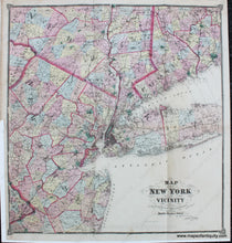
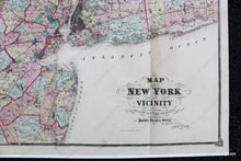
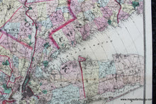
Antique hand colored maps of New York and vicinity, accompanying the Atlas of New York and Vicinity, by Beers, Ellis, & Soule. A wonderful view of the vicinity of New York City, including parts of New Jersey, Pennsylvania, and Connecticut. Colored by town with narrower color boundaries indicating counties and wider color boundaries showing state lines. Concentric circles indicate the distance from City Hall in NYC Manhattan in 5 mile increments. Good to very good antique condition with some minor tears archivally repaired, some mild staining consistent with age. Folds as issued.   Will look impressive when framed. Measures approx. 30.25 x 27.5 inches to the decorative border.


Item Number: NYO189