CLOSED ON JULY 4TH! Current hours: 10am to 5pm Monday through Saturday and 12-5 on Sundays. Proud to be a SMALL, LOCAL, CAPE COD BUSINESS! Maps of Antiquity is in its 38th year! Our maps are only available at our website www.mapsofantiquity.com or at our store!

Genuine-Antique-Hand-drawn-Map-Framed-Map-of-Palestine-by-J-Washburn-Hebron-Nov-22-1830-1830-J-Washburn-after-Finley-Maps-Of-Antiquity
1830 - Map of Palestine; by J. Washburn; Hebron: Nov 22 1830 - Genuine Antique Hand-drawn Map, Framed
  • Load image into Gallery viewer, Genuine-Antique-Hand-drawn-Map-Framed-Map-of-Palestine-by-J-Washburn-Hebron-Nov-22-1830-1830-J-Washburn-after-Finley-Maps-Of-Antiquity
  • Load image into Gallery viewer, 1830 - Map of Palestine; by J. Washburn; Hebron: Nov 22 1830 - Genuine Antique Hand-drawn Map, Framed
  • Load image into Gallery viewer, 1830 - Map of Palestine; by J. Washburn; Hebron: Nov 22 1830 - Genuine Antique Hand-drawn Map, Framed
  • Load image into Gallery viewer, 1830 - Map of Palestine; by J. Washburn; Hebron: Nov 22 1830 - Genuine Antique Hand-drawn Map, Framed

1830 - Map of Palestine; by J. Washburn; Hebron: Nov 22 1830 - Genuine Antique Hand-drawn Map, Framed

Regular price
$2,100.00
Sale price
$2,100.00
Regular price
Sold out
Unit price
per 
Shipping calculated at checkout.

Item number: CSMT284

Genuine Antique Hand-drawn Map, Framed

1830

Maker: J. Washburn after Finley


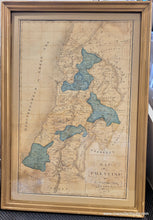
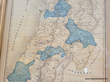
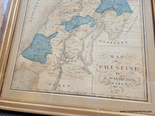
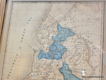
Genuine antique "schoolgirl map" of Palestine done by J. Washburn of Hebron. This map appears to have been created based on the Finley map of Palestine, published in 1824 and 1827. The young Miss Washburn added some artistic flourishes particularly around the title, but also adjusted some of the wording to arch and flow beautifully over the page. Handsomely rendered in a combination of pencil and pen, with watercolor. Includes the Dead Sea, Gaza, Jerusalem, the Sea of Galilee, Damascus, and more. Shows the Twelve Tribes of Israel with the names and colors, although much of the color has faded over time. Good antique condition with some mild water staining in the lower left and upper right corners, some small spots, some mild wrinkles at bottom, and other minor signs of age. Currently framed and should be re-framed. Measures approx. 20 x 12.75 inches to the neatline and 23.75 x 16.5 inches total including the frame. Framed with antique glass (slightly wavy with some tiny bubbles) which makes it difficult to take a photo without glare. 

Genuine Antique Hand-drawn Map, Framed from 1830

Item Number: CSMT284