Pickup available at 1409 MAIN ST, CHATHAM MA
Usually ready in 24 hours
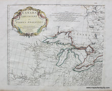
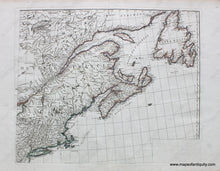
1755 - Canada Louisiane et Terres Angloises - Antique Maps
-
1409 MAIN ST, CHATHAM MA
Pickup available, usually ready in 24 hours1409 Main Street
Chatham MA 02633
United States+15089451660
1755
Maker: D'Anville.
Set of two joinable antique hand colored maps showing parts of Canada and the northern United States, by D'Anville, 1755. These maps are part of a four map set, however only two are currently available. Shows from Newfoundland south to New York including New Brunswick, Nova Scotia, Prince Edward Island, the Saint Lawrence River, the Great Lakes, and as far west as just beyond the Mississippi River. In the west, the areas are named after the native peoples. The Mississippi River has a note that the source is still unknown. These maps represent a time in the continent's history when the white settlers were exploring towards the west via river and settlements were almost exclusively on rivers or oceans as methods of access. Very good overall antique condition. Color is almost certainly not original. Each map is approx. 19 x 22 inches to the neatline. **NOTE- because this map requires extra insurance for shipping, an additional charge will appear on your card after your original purchase. If you would like to know what that charge will be, please contact us.**
Item Number: CAN229


