Genuine-Antique-Map-Moll-Beaver-Map-A-New-and-Exact-Map-of-the-Dominions-of-the-King-of-Great-Britain-on-ye-Continent-of-North-America-1733-Moll-Maps-Of-Antiquity
  • Load image into Gallery viewer, Genuine-Antique-Map-Moll-Beaver-Map-A-New-and-Exact-Map-of-the-Dominions-of-the-King-of-Great-Britain-on-ye-Continent-of-North-America-1733-Moll-Maps-Of-Antiquity
  • Load image into Gallery viewer, Genuine-Antique-Map-Moll-Beaver-Map-A-New-and-Exact-Map-of-the-Dominions-of-the-King-of-Great-Britain-on-ye-Continent-of-North-America-1733-Moll-Maps-Of-Antiquity
  • Load image into Gallery viewer, Genuine-Antique-Map-Moll-Beaver-Map-A-New-and-Exact-Map-of-the-Dominions-of-the-King-of-Great-Britain-on-ye-Continent-of-North-America-1733-Moll-Maps-Of-Antiquity
  • Load image into Gallery viewer, Genuine-Antique-Map-Moll-Beaver-Map-A-New-and-Exact-Map-of-the-Dominions-of-the-King-of-Great-Britain-on-ye-Continent-of-North-America-1733-Moll-Maps-Of-Antiquity
  • Load image into Gallery viewer, Genuine-Antique-Map-Moll-Beaver-Map-A-New-and-Exact-Map-of-the-Dominions-of-the-King-of-Great-Britain-on-ye-Continent-of-North-America-1733-Moll-Maps-Of-Antiquity
  • Load image into Gallery viewer, Genuine-Antique-Map-Moll-Beaver-Map-A-New-and-Exact-Map-of-the-Dominions-of-the-King-of-Great-Britain-on-ye-Continent-of-North-America-1733-Moll-Maps-Of-Antiquity
  • Load image into Gallery viewer, Genuine-Antique-Map-Moll-Beaver-Map-A-New-and-Exact-Map-of-the-Dominions-of-the-King-of-Great-Britain-on-ye-Continent-of-North-America-1733-Moll-Maps-Of-Antiquity
  • Load image into Gallery viewer, Genuine-Antique-Map-Moll-Beaver-Map-A-New-and-Exact-Map-of-the-Dominions-of-the-King-of-Great-Britain-on-ye-Continent-of-North-America-1733-Moll-Maps-Of-Antiquity
  • Load image into Gallery viewer, Genuine-Antique-Map-Moll-Beaver-Map-A-New-and-Exact-Map-of-the-Dominions-of-the-King-of-Great-Britain-on-ye-Continent-of-North-America-1733-Moll-Maps-Of-Antiquity
  • Load image into Gallery viewer, Genuine-Antique-Map-Moll-Beaver-Map-A-New-and-Exact-Map-of-the-Dominions-of-the-King-of-Great-Britain-on-ye-Continent-of-North-America-1733-Moll-Maps-Of-Antiquity
  • Load image into Gallery viewer, Genuine-Antique-Map-Moll-Beaver-Map-A-New-and-Exact-Map-of-the-Dominions-of-the-King-of-Great-Britain-on-ye-Continent-of-North-America-1733-Moll-Maps-Of-Antiquity
  • Load image into Gallery viewer, Genuine-Antique-Map-Moll-Beaver-Map-A-New-and-Exact-Map-of-the-Dominions-of-the-King-of-Great-Britain-on-ye-Continent-of-North-America-1733-Moll-Maps-Of-Antiquity

1733 - Moll's "Beaver Map" - A New and Exact Map of the Dominions of the King of Great Britain on ye Continent of North America… - Antique Map

Regular price
$11,500.00
Sale price
$11,500.00
Regular price
Sold out
Unit price
per 
Shipping calculated at checkout.

Item number: NEW204
Genuine Antique Map

1733

Maker: Moll

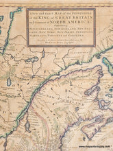
 Full Title: A New and Exact Map of the Dominions of the King of Great Britain on ye Continent of North America. Containing Newfoundland, New Scotland, New England, New York, New Jersey, Pensilvania, Maryland, Virginia and Carolina.

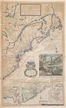
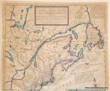
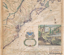
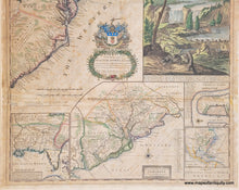
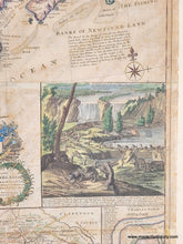
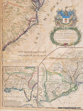
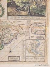
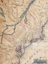
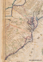
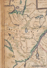
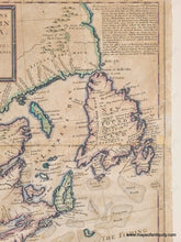
A famous, desirable, and highly collectible antique map of eastern North America from St Augustine, FL to Newfoundland, with the colonies of Carolina, Virginia, Maryland, Pennsylvania, East and West New Jersey, New York, and New England. This is the circa 1733 state of this map, with Moll's name removed in the space under the scale of miles, and instead says "Printed and Sold by Thos. Bowles . . . John Bowles . . . and I King..." and the Carolina inset is divided into counties. Made by Herman Moll and first issued in 1715 with about ten states (editions) published between 1715 and 1753. Moll's so-called Beaver map was published in his world atlas, and is "among the first and most important documents relating to the ongoing dispute between France and Great Britain over boundaries separating their respective American Colonies." It shows the British position following the Treaty of Utrecht of 1713, when Britain acquired the Atlantic seaboard of Northeast America. Showing not only notations relating to territorial claims, Indian tribes, the fur trade, but also the 18th Century postal routes, it is considered the first postal map of the American colonies. Of course, the map acquired its unique moniker from the vignette showing Niagara Falls with beavers at work. Beaver pelts were a significant part of a highly successful American fur trade, an industry that was used to promote settlement in America. The beavers are shown walking on their hind legs and carrying the wood over their shoulders and dragging earth or rocks on their tails, a delightfully absurd guess on the part of the artist as to how beavers built dams. Inset maps of the Gulf of Mexico showing Florida and Louisiana Territory, Carolina (before North and South separated), Charleston SC, and A Map of the Principal Part of North America. This map is in good to very good restored condition, with some toning, foxing, repaired separations, and wear at the paper edges- all common signs of its age and importance. Measures approx. 40 x 24 inches to the neatline.

Little about Herman Moll's early life is known. He was born in either Germany or the Netherlands and ended up in London in 1678 where he was recorded working as an engraver. Moll later specialized in engraving maps and went on to become one of the most well-known cartographers in England of his generation.

Item Number: NEW204