1892
Maker: Home Library & Supply Association.
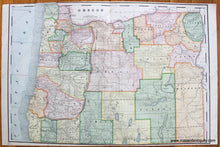
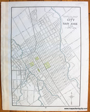
Antique printed color 2-page map of the state of Oregon, published in "The Pacific Coast and the World" by the Home Library and Supply Association, 1892. Map is colored by county and includes topographical detail, locations of Indian Reservations, railroads, etc. With fold, as issued. On Verso: A 1-page map of San Jose, California showing an overview of city blocks, names of major streets, railroads, and points of interest (e.g. Convent of Notre Dame, Washington Square, etc.) Published in "The Pacific Coast and the World" by the Home Library and Supply Association, 1892. Fair to good overall antique condition with some very mild toning/foxing/spots/stains. Maps are printed slightly off square with the paper. Map of Oregon measures approximately 14" x 20.5" (H x W) to the neatline. Map of San Jose measures approx. 13" x 9" to the neatline. Priced as-is.
Item Number: WES294


