CLOSED THURSDAY MARCH 27th! SORRY FOR ANY INCONVENIENCE! Current hours: 10am to 5pm Tuesday through Saturday. We are closed Sundays and Mondays for the Winter. Proud to be a SMALL, LOCAL, CAPE COD BUSINESS! Maps of Antiquity is in its 38th year! Our maps are only available at our website www.mapsofantiquity.com or at our store!

Hand-Colored-Printed-Map-A-Topographic-Portrait-of-Martha's-Vineyard--Massachusetts-Martha's-Vineyard-1985-Dana-Gaines-Maps-Of-Antiquity
1985 - A Topographic Portrait Of Martha’s Vineyard Antique Map Hand-Colored Printed
  • Load image into Gallery viewer, Hand-Colored-Printed-Map-A-Topographic-Portrait-of-Martha's-Vineyard--Massachusetts-Martha's-Vineyard-1985-Dana-Gaines-Maps-Of-Antiquity
  • Load image into Gallery viewer, 1985 - A Topographic Portrait Of Martha’s Vineyard Antique Map Hand-Colored Printed

1985 - A Topographic Portrait of Martha's Vineyard - Antique Map

Regular price
$155.00
Sale price
$155.00
Regular price
Sold out
Unit price
per 
Shipping calculated at checkout.
 More payment options

Pickup available at 1409 MAIN ST, CHATHAM MA

Usually ready in 24 hours

Item number: MAS1700
Hand Colored Printed Map

1985

Maker: Dana Gaines.


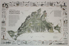
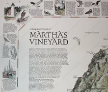
Hand colored printed map of Martha's Vineyard created in 1985 by Dana Gaines, showing landforms, roads and towns, with geological and historical information, as well as information on wildlife and many major points of interest. Dry mounted, printed area measures approx. 19 x 28 inches. In store pick-up only. Currently unmatted for $155.00. If custom matted, $185.00 please contact us by phone or email to order this item matted. **May require additional time**


Item Number: MAS1700