Winter hours: Tuesday - Saturday 10am to 5pm. Close Sundays and Mondays until May. We appreciate your business!

Genuine-Antique-Folding-Map-Paris-ses-Monuments-Towns-and-Cities-Paris-1925-Borremans-/-Taride-Maps-Of-Antiquity-1800s-19th-century
  • Load image into Gallery viewer, Genuine-Antique-Folding-Map-Paris-ses-Monuments-Towns-and-Cities-Paris-1925-Borremans-/-Taride-Maps-Of-Antiquity-1800s-19th-century
  • Load image into Gallery viewer, Genuine-Antique-Folding-Map-Paris-ses-Monuments-Towns-and-Cities-Paris-1925-Borremans-/-Taride-Maps-Of-Antiquity-1800s-19th-century
  • Load image into Gallery viewer, Genuine-Antique-Folding-Map-Paris-ses-Monuments-Towns-and-Cities-Paris-1925-Borremans-/-Taride-Maps-Of-Antiquity-1800s-19th-century

1925 - Paris ses Monuments - Antique Map

Regular price
$250.00
Sale price
$250.00
Regular price
Sold out
Unit price
per 
Shipping calculated at checkout.

Item number: TOW656
Genuine Antique Folding Map

c. 1925

Maker: Borremans / Taride.


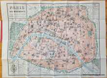
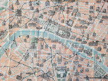
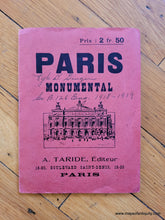
Antique printed color map of Paris, France, by F. Borremans and published by A. Taride, c. 1925 (undated). This handsome map features illustrations of notable buildings and monuments, roads, railroads, and the Metro system. The map is undated but the approximate year can be inferred by the Metro System. Includes the Lourve, Notre-Dame, the Eiffel Tower, gardens, parks, the city walls, and more. Good antique condition with wear along the fold lines and some small separations at fold intersections. Original paper jacket is attached and can be folded under when framing. Measures approx. 21.5 x 27.5 inches to the neatline.


Item Number: TOW656