Current hours: 10am to 5pm Monday through Saturday. 12pm to 5pm Sundays. IMPORTANT PLEASE NOTE: We have become aware that some of our photos have been stolen by other websites. Our maps are only available at our website www.mapsofantiquity.com or at our store!

Genuine-Antique-Colored-Map-Boston-Harbor--United-States-Boston-c.-1900-Walker-Maps-Of-Antiquity-1800s-19th-century
  • Load image into Gallery viewer, Genuine-Antique-Colored-Map-Boston-Harbor--United-States-Boston-c.-1900-Walker-Maps-Of-Antiquity-1800s-19th-century
  • Load image into Gallery viewer, Genuine-Antique-Colored-Map-Boston-Harbor--United-States-Boston-c.-1900-Walker-Maps-Of-Antiquity-1800s-19th-century

1900 - Boston Harbor - Antique Map

Regular price
$275.00
Sale price
$275.00
Regular price
Sold out
Unit price
per 
Shipping calculated at checkout.

Item number: TOW223
Genuine Antique Colored Map

c. 1900

Maker: Walker.


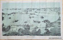
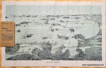
Antique Bird's Eye View map of Boston Harbor, in color, by Walker, circa 1900, from South Boston, looking east to the Boston Harbor Islands and South. Islands are labelled and includes Nantasket Beach and Minots Light in the far distance. Measures approximately 12 x 21 inches. Good overall antique condition with some separations at fold intersections and one longer separation along a fold on left side (repaired with archival tape). Paper is somewhat fragile and should be handled carefully. Map is attached to a paper booklet cover that can be folded under when framing. 


Item Number: TOW223