Current hours: 10am to 5pm Tuesday through Saturday. We are closed Sundays and Mondays for the Winter. Proud to be a SMALL, LOCAL, CAPE COD BUSINESS! Maps of Antiquity is in its 38th year! Our maps are only available at our website www.mapsofantiquity.com or at our store!

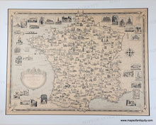
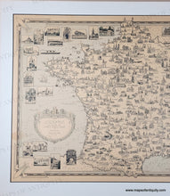
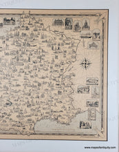
Map of France from the 1930s with detailed illustrations of buildings throughout. The paper is a light tan color from age and there is a light blue color printed in the ocean and some other small areas around the border. Light green printed color in the greenery around the title
1935 - France as Drawn by Ernest Dudley Chase  - Antique Pictorial Map
  • Load image into Gallery viewer, Map of France from the 1930s with detailed illustrations of buildings throughout. The paper is a light tan color from age and there is a light blue color printed in the ocean and some other small areas around the border. Light green printed color in the greenery around the title
  • Load image into Gallery viewer, 1935 - France as Drawn by Ernest Dudley Chase  - Antique Pictorial Map
  • Load image into Gallery viewer, 1935 - France as Drawn by Ernest Dudley Chase  - Antique Pictorial Map

1935 - France as Drawn by Ernest Dudley Chase - Antique Pictorial Map

Regular price
$550.00
Sale price
$550.00
Regular price
Sold out
Unit price
per 
Shipping calculated at checkout.
 More payment options

Pickup available at 1409 MAIN ST, CHATHAM MA

Usually ready in 24 hours

Item number: CSMT261

Genuine Antique Printed-Color Pictorial Map

c. 1935

Maker: Ernest Dudley Chase.


Charming, illustrated antique pictorial map by Ernest Dudley Chase. With Fleurs de Lis at the corners of the decorative border. Shows detailed views of important architectural buildings throughout the country with additional notable buildings depicted larger at the sides of the map. Light blue printed color wash is the only color. This map has been dry mounted on a board. Highly collectible. Good condition with toning. and some tears at the paper edges that were closed when the map was mounted. Matted- mat was stuck down to map and the surface of the paper has slightly torn away at the edges. Map is approx. 17 x 23 inches to the decorative border.

Genuine Antique map from c. 1935

Item Number: CSMT261