Current hours: 10am to 5pm Monday through Saturday. 12pm to 5pm Sundays. IMPORTANT PLEASE NOTE: We have become aware that some of our photos have been stolen by other websites. Our maps are only available at our website www.mapsofantiquity.com or at our store!

1939 - The New York 1939 Official World's Fair Pictorial Map - Antique Pictorial Map
  • Load image into Gallery viewer, 1939 - The New York 1939 Official World's Fair Pictorial Map - Antique Pictorial Map
  • Load image into Gallery viewer, 1939 - The New York 1939 Official World's Fair Pictorial Map - Antique Pictorial Map
  • Load image into Gallery viewer, 1939 - The New York 1939 Official World's Fair Pictorial Map - Antique Pictorial Map

1939 - The New York 1939 Official World's Fair Pictorial Map - Antique Pictorial Map

Regular price
$75.00
Sale price
$75.00
Regular price
Sold out
Unit price
per 
Shipping calculated at checkout.

Item number: OTH362A

Genuine Antique Pictorial Map

1939

Maker: Tony Sarg.


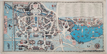
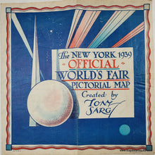
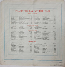
Antique printed color map for the 1939 World's Fair in New York City. This seems to be a simplified version of the booklet (OTH362) that was probably offered as a less expensive pamphlet version. It includes an Index of Exhibits for the 1939 World's Fair. It was held at Flushing Meadows-Corona Park in Queens, New York. This map shows an overview of the fair itself. Fair condition with three vertical folds, wrinkling, some wear at the paper edges, and some pencil marks in the index, probably from the original owner marking off exhibits they saw. Color may be faded. Measures approx. 10.5 x 21.25 inches to the neatline. 


Item Number: OTH362A