Current hours: 10am to 5pm Monday through Saturday. 12pm to 5pm Sundays. IMPORTANT PLEASE NOTE: We have become aware that some of our photos have been stolen by other websites. Our maps are only available at our website www.mapsofantiquity.com or at our store!

Printed-Color-Antique-Folding-Map-A-Map-of-Olde-Boston-Towne-United-States-New-York-1930-Raymond-Luskin-Maps-Of-Antiquity
1930 - A Map of Olde Boston Towne - Antique Map
  • Load image into Gallery viewer, Printed-Color-Antique-Folding-Map-A-Map-of-Olde-Boston-Towne-United-States-New-York-1930-Raymond-Luskin-Maps-Of-Antiquity
  • Load image into Gallery viewer, 1930 - A Map of Olde Boston Towne - Antique Map
  • Load image into Gallery viewer, 1930 - A Map of Olde Boston Towne - Antique Map

1930 - A Map of Olde Boston Towne - Antique Map

Regular price
$245.00
Sale price
$245.00
Regular price
Sold out
Unit price
per 
Shipping calculated at checkout.

Item number: TOW228
Printed Color Genuine Antique Folding Map

1930

Maker: Luskin.

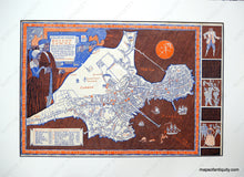
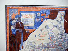
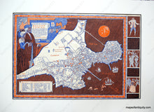
Colorful and whimsical commemorative map commissioned by Filene's to celebrate Boston's Tercentenary in 1930. Drawn by Raymond Luskin, its cartouche states that it shows "street locations, inns, taverns, graveyards, gibbets and the like with here and there a hint of the costumes and mode of living of the time." Text mimics 17th century English and border illustrations humorously note Puritanical dress codes. Verso is a brochure displaying the many flags associated with the early United States around the time of the Revolution. Map area measures 12 X 18 inches.

Item Number: TOW228